July Rainfall Surplus in J&K & Ladakh: 35% Excess in J&K, 71% in Kashmir and 297% in Ladakh
By: News Desk | 07 Aug 2026
July Rainfall Surplus in J&K & Ladakh: When a Wet Month Becomes a Warning
July 2026 has delivered an unusual rainfall pattern across Jammu & Kashmir and Ladakh.
According to the rainfall figures supplied for this analysis, Jammu & Kashmir recorded a 35% surplus during July, while the Kashmir Division received 89.9 mm against a normal 52.5 mm—71% above normal.
The most striking anomaly came from Ladakh. The Union Territory recorded 25.8 mm against a normal of 6.5 mm, translating into an extraordinary 297% surplus.
On paper, surplus rainfall can sound like good news for a water-stressed Himalayan region. But rainfall is not simply about how much water falls. Where it falls, how quickly it falls and how saturated the ground already is can determine whether rain becomes a resource—or a hazard.
July’s weather demonstrated precisely that dilemma.
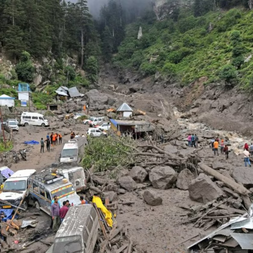
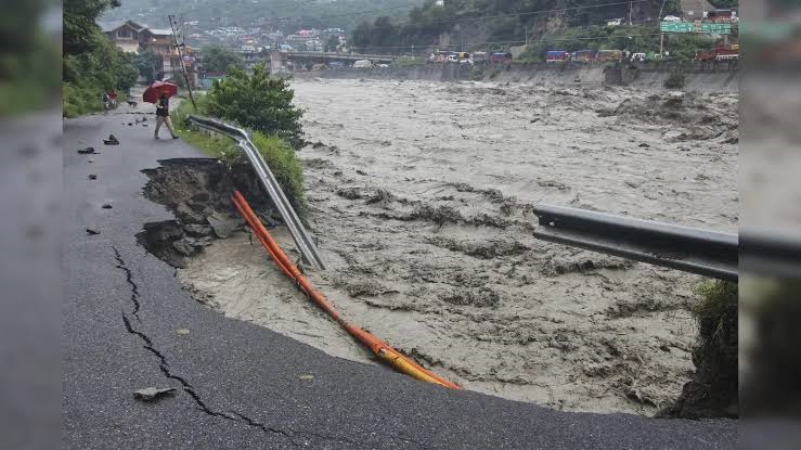
The region witnessed repeated episodes of heavy rain, landslides, flash flooding and disruption to critical roads. The Jammu-Srinagar National Highway was repeatedly affected by landslides and shooting stones, while the Amarnath Yatra was temporarily suspended because of unsafe weather and route conditions.
Kashmir and Ladakh Rainfall: The Numbers Behind the July Anomaly
The supplied rainfall dataset presents a sharp contrast between normal July precipitation and actual rainfall.
| Region | Normal Rainfall | Actual Rainfall | Surplus |
|---|---|---|---|
| Kashmir Division | 52.5 mm | 89.9 mm | 71% |
| Ladakh | 6.5 mm | 25.8 mm | 297% |
| J&K Overall | — | — | 35% |
The Ladakh figure is particularly striking because its normal July rainfall is extremely low compared with Kashmir.
A relatively small absolute increase in rainfall can therefore translate into a very large percentage anomaly.
This distinction is important.
A 297% surplus does not mean Ladakh received 297% more rain in absolute terms than Kashmir
It means rainfall was nearly four times its stated normal level.
For a normally dry high-altitude environment, such a departure can have outsized consequences because local drainage, slopes, roads and settlements are not necessarily designed for repeated heavy precipitation.
Why Ladakh’s 297% Rainfall Surplus Matters
Ladakh is one of India’s cold-desert landscapes. Its ecosystems, agriculture and settlements have historically developed around limited precipitation and seasonal snowmelt.
That makes unusually wet periods particularly significant.
Rainfall can replenish soil moisture and local water sources, but intense or concentrated rainfall can also produce:
- Flash floods in narrow valleys
- Mud and debris flows
- Slope instability
- Road damage
- Soil erosion
- Agricultural losses
- Disruption to remote communities
The key climate question is therefore not simply whether Ladakh is becoming wetter.
It is whether precipitation is becoming more variable and concentrated in extreme events.
That distinction is critical for climate adaptation in the Himalayas.
Kashmir’s 71% Rainfall Surplus Brings Both Relief and Risk
For Kashmir, additional rainfall can provide benefits to agriculture and water resources, particularly after periods of high temperatures or relatively dry conditions.
Paddy and maize cultivation can benefit from adequate soil moisture, while mountain streams and local water systems receive additional recharge.
But excess rainfall becomes problematic when the ground cannot absorb it quickly enough.
In Kashmir’s mountainous terrain, steep slopes, fragile geology and road-cuttings can make prolonged rainfall a trigger for landslides.
July’s events offered a clear demonstration.
The Jammu-Srinagar National Highway was repeatedly disrupted by landslides, mudslides and shooting stones following persistent rainfall. On July 22, traffic was suspended along the strategic highway after multiple landslides affected several points between Udhampur and Banihal.
Jammu-Srinagar Highway: Rain Turns a Lifeline into a Vulnerability
The approximately 250-km Jammu-Srinagar highway is more than a road.
It is Kashmir’s principal surface connection with the rest of the country and carries passengers, tourists, food supplies, fuel and other essential commodities.
When heavy rain destabilises its slopes, the consequences quickly spread beyond transportation.
A highway closure can mean:
- Hundreds of vehicles stranded
- Delays in essential supplies
- Higher transport costs
- Disruption to tourism
- Difficulties for emergency services
- Problems for pilgrims travelling to Kashmir
The vulnerability was evident again later in July when a fresh landslide blocked the highway in Udhampur. Authorities had to regulate traffic and deploy machinery to clear the affected stretch.
This recurring pattern raises a larger infrastructure question: Can Himalayan roads designed primarily for connectivity also be made resilient enough for a future of increasingly unpredictable rainfall?
Amarnath Yatra Faces Weather Disruptions
The unusually wet conditions also affected one of Jammu & Kashmir’s most important annual religious journeys.
The Amarnath Yatra was suspended for six days from July 19 because of persistent rainfall and hazardous conditions along the Pahalgam and Baltal routes.
The pilgrimage resumed on July 25 after weather conditions improved and the Jammu-Srinagar highway became operational following a three-day closure caused by landslides and shooting stones.
The episode illustrates how extreme weather can simultaneously affect:
- Religious tourism
- Local transport
- Hospitality businesses
- Security arrangements
- Road maintenance
- Emergency response systems
In the Himalayas, tourism planning can no longer treat extreme weather as an occasional interruption.
It has to be part of the operating model.
Agriculture: Rainfall Can Help—Until It Becomes Too Much
For farmers, surplus rainfall presents a mixed picture.
Potential Benefits
Adequate rain can:
- Improve soil moisture.
- Reduce irrigation requirements.
- Support paddy cultivation.
- Benefit maize and other crops.
- Replenish local water sources.
But prolonged rainfall can reverse those gains.
The Risks
Excess moisture may cause:
- Waterlogging
- Root damage
- Fungal disease
- Nutrient loss
- Soil erosion
- Crop lodging
Horticulture is particularly vulnerable.
Kashmir’s apple orchards depend on carefully balanced moisture conditions. Heavy and persistent rainfall can increase disease pressure and affect fruit quality, particularly where drainage is inadequate.
The lesson is simple: farmers need predictable water more than simply more water.
Tourism Gets a Mixed Weather Message
Rainfall is not necessarily bad news for Kashmir tourism.
For visitors, rain can transform the landscape.
Gulmarg’s meadows become greener, mountain streams swell, and Pahalgam’s valleys take on a dramatic, mist-covered appearance.
But heavy rainfall can also create logistical uncertainty.
Tourists may face:
- Road closures
- Delayed transport
- Landslide risks
- Cancelled excursions
- Temporary restrictions on trekking
- Disruptions to pilgrimage routes
The same rainfall that makes Kashmir visually spectacular can therefore make travelling through the region more difficult.
For tourism operators, the priority should be shifting from simply promoting scenic weather to providing real-time weather and road information.
The Climate Change Question: Is This the New Himalayan Normal?
One unusually wet month cannot by itself prove that climate change caused the rainfall surplus.
That distinction matters.
Climate science requires long-term datasets to establish trends.
However, the increasing concern among scientists and disaster managers is the growing importance of weather extremes—including intense rainfall, flash floods, landslides and cloudbursts—in a warming Himalayan environment.
Recent July events underline the region’s vulnerability.
A series of cloudbursts, flash floods and landslides caused major damage in several mountainous areas of Jammu & Kashmir, including Poonch, Rajouri and Kishtwar. Contemporary reporting documented deaths, damaged homes and infrastructure, and major disruption to communities.
This does not mean every heavy rainfall event should automatically be labelled a consequence of climate change.
But it does mean infrastructure and disaster planning must account for the possibility of more volatile precipitation patterns.
Why the Himalayas Are Particularly Vulnerable
The Himalayan environment combines several natural risk factors.
Steep Terrain
Water moves rapidly downhill, leaving little time for absorption during intense rainfall.
Fragile Slopes
Road construction, deforestation, construction activity and natural geological processes can weaken slopes.
Narrow Valleys
Settlements and roads are often concentrated along river valleys, increasing exposure to floods and debris flows.
Changing Cryosphere
Warming temperatures are altering snow and ice dynamics, which can interact with rainfall and runoff patterns.
Expanding Infrastructure
More roads, tourism facilities and settlements mean more people and assets are exposed to mountain hazards.
The result is a risk equation in which extreme rainfall can have consequences far beyond the rainfall itself.
From Rainfall Data to Climate Resilience
The July rainfall surplus should therefore not be viewed only as a meteorological statistic.
It should become a planning signal.
Authorities need to strengthen:
Early-Warning Systems
Communities in landslide- and flood-prone areas need warnings that are fast, localised and actionable.
Slope Monitoring
High-risk highway corridors should receive continuous geological and rainfall monitoring.
Drainage Infrastructure
Roadside drains, culverts and channels must be designed and maintained to handle intense rainfall rather than historical averages alone.
Climate-Resilient Roads
New highway projects should incorporate slope stabilisation, improved drainage and debris-flow protection.
Wetland Protection
Wetlands and natural floodplains can absorb and slow water. Their destruction can increase urban flood risk.
Disaster-Ready Tourism
Tourism operators should integrate weather alerts, route conditions and emergency evacuation procedures into travel planning.
A Wet July Is Also a Warning for Urban Kashmir
Srinagar and other growing urban centres face a separate challenge.
Rapid construction has reduced natural drainage in several areas, while intense rainfall can overwhelm stormwater systems.
When rainfall arrives in short, intense bursts, even a city that receives moderate total monthly rainfall can experience severe flooding.
Urban planning therefore needs to move beyond simply measuring annual or monthly rainfall.
The more useful questions are:
How intense was the rainfall?
How long did it last?
Where did it occur?
Was the soil already saturated?
Could drainage systems handle the runoff?
These indicators provide a much better understanding of actual flood risk.
What July 2026 Should Teach J&K and Ladakh
The rainfall figures tell two different stories.
For agriculture and water resources, surplus rain can be valuable.
For mountain infrastructure and vulnerable communities, the same surplus can become dangerous.
That contradiction is at the heart of Himalayan climate resilience.
The goal should not be to prevent rainfall or fear every wet spell. Instead, the region needs systems capable of absorbing, storing, redirecting and safely managing excess water.
Outlook: The Challenge Is Not Too Much Rain—It Is Too Much Uncertainty
July 2026 has shown how quickly weather can move from beneficial to disruptive across Jammu & Kashmir and Ladakh.
The supplied rainfall data puts the regional surplus at 35%, with 71% excess in Kashmir Division and 297% in Ladakh. While the precise regional percentages should be checked against the final official monthly rainfall bulletin before publication, the broader weather pattern and its consequences are clear: heavy rainfall contributed to landslides, road disruptions and a temporary suspension of the Amarnath Yatra.
For the Himalayas, the bigger story is not simply that July was wet.
It is that rainfall is becoming a more consequential risk when it arrives intensely, repeatedly and in places where infrastructure and ecosystems have limited capacity to cope.
The response must therefore combine better forecasting with better land-use planning, stronger roads, healthier watersheds and faster disaster response.
Because in the Himalayas, the question is no longer simply how much rain will fall.
It is whether the mountains, communities and infrastructure will be ready when it does.