Nepal Flash Flood Disaster: 160+ Dead as Glacier Collapse Sends Wall of Water Across Himalayas
By: News Desk | 27 August 2026
A catastrophic flash flood tore through Nepal’s northern Rasuwa district on August 26, sending a violent surge of water, mud, ice and rock down the Bhote Koshi corridor and into downstream communities. More than 160 people are now reported dead across Nepal and the adjoining Tibet region, while hundreds remain unaccounted for, including foreign tourists and pilgrims.
The disaster has exposed a dangerous convergence of fragile Himalayan terrain, rapidly changing cryospheric conditions, settlements and infrastructure concentrated along narrow river valleys, and limited warning time.
But one part of the initial narrative needs careful correction.
Early reports suggested that an earthquake had triggered the disaster. Subsequent analysis, including updated US Geological Survey information, points instead toward an ice-and-rock avalanche or glacial collapse that temporarily blocked a river before the blockage failed and released a devastating surge downstream. The exact sequence is still being investigated.
Nepal Flash Flood: What Happened on August 26?
The disaster struck at approximately 9 a.m. local time on Wednesday, August 26, in the Rasuwa district of northern Nepal, close to the border with China’s Tibet Autonomous Region.
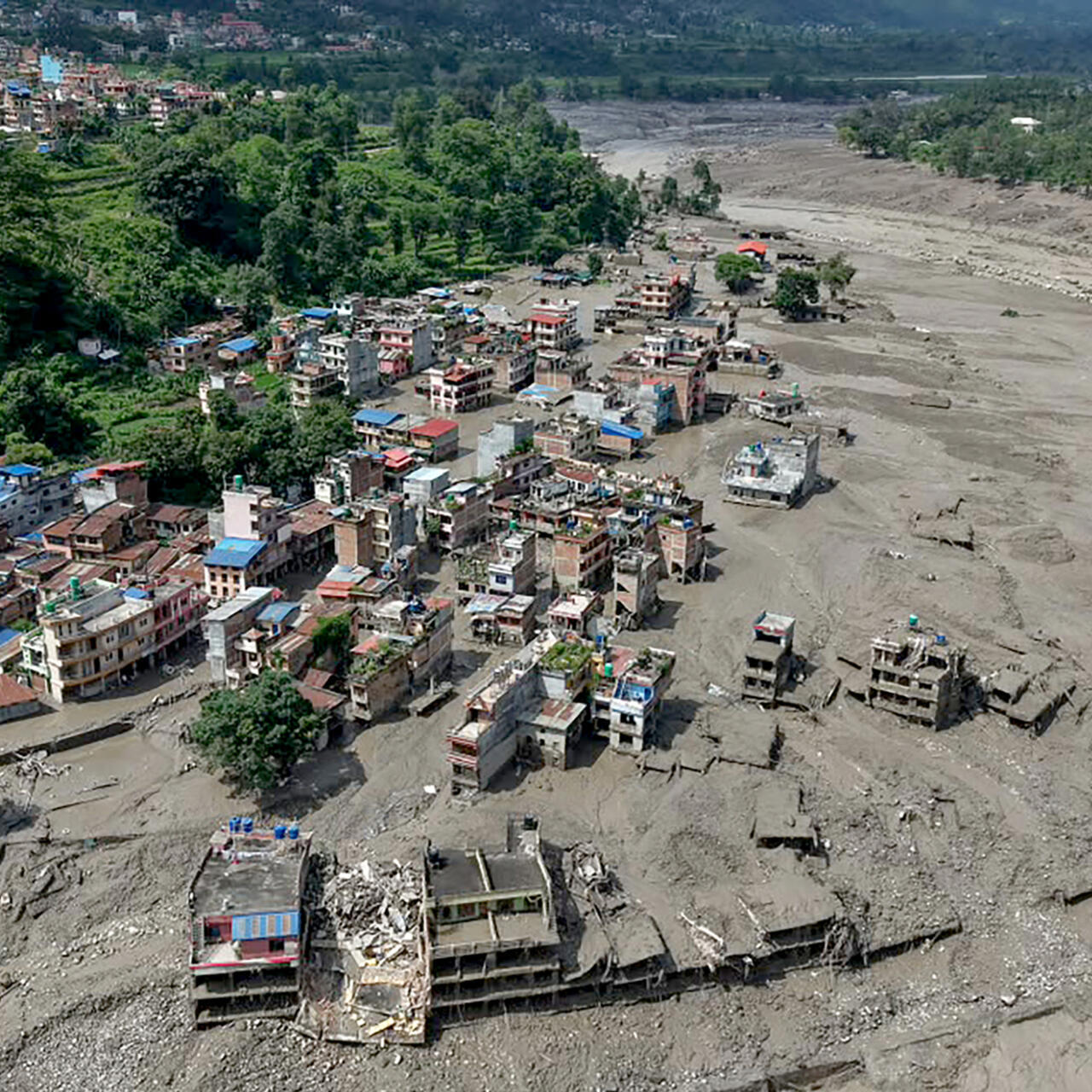
A sudden wall of water and debris surged through the Bhote Koshi river system, devastating areas around Timure, Syaphrubesi and other settlements before the floodwaters moved downstream toward Nuwakot, Dhading and the Trishuli corridor.
Witnesses and officials described the event as exceptionally sudden.
Buildings, vehicles, roads, bridges, customs facilities and power infrastructure were swept away or buried under mud and debris.
The destruction was particularly severe because communities and critical infrastructure are concentrated along narrow Himalayan valleys, leaving little room for a fast-moving flood to disperse safely.
Was the Flood Caused by a Glacier Collapse?
This is perhaps the most important scientific question surrounding the disaster.
The first reports were complicated by conflicting explanations.
A seismic event was initially considered a possible trigger. Nepalese officials reported an earthquake in the region around the time of the disaster, while early reports suggested that it could have caused a landslide.
But subsequent USGS analysis revised that interpretation, pointing instead toward a glacial collapse/ice-rock avalanche.
Nepal’s Department of Hydrology and Meteorology also said preliminary satellite imagery indicated that debris had blocked the river roughly 20 kilometres upstream of the Miteri Bridge, apparently creating a temporary lake before the blockage suddenly failed.
That sequence is crucial.
The likely chain of events
Glacial or ice-rock collapse → debris enters river → temporary blockage → water accumulates → blockage fails → high-energy flood surge → downstream destruction
This is different from an ordinary monsoon flood.
There is also an important distinction between a glacial lake outburst flood (GLOF) and a flood caused by an ice-rock avalanche that temporarily dams a river.
The precise mechanism in this case remains under investigation, so describing it simply as a “glacial lake outburst” would be premature.
Death Toll Is Still Changing
The casualty figures have evolved rapidly because communications were cut and many affected locations became inaccessible.
Nepal Police reported 157 bodies recovered, while the Chinese side reported three deaths in Tibet’s Gyirong area. That produced an initial cross-border toll of at least 160.
However, later reports have put Nepal’s death toll at 162, meaning the combined toll could already be higher.
This is why the safest publication wording is:
More than 160 people have been reported dead across Nepal and Tibet, with the toll expected to change as search operations continue.
Hundreds of people remain unaccounted for.
The uncertainty is not simply administrative. Entire sections of roads and settlements were destroyed, communications were interrupted and rescue teams have had difficulty reaching some of the worst-hit locations.
Hundreds of Foreign Tourists and Pilgrims Missing
The disaster has taken on an international dimension because the affected corridor is used by tourists, trekkers and pilgrims travelling toward Gosaikunda and the Kailash Mansarovar pilgrimage route.
The Nepal Tourism Board initially reported 403 tourists out of contact, including 341 foreign nationals and 62 Nepali travellers.
Among those reported missing were:
- 133 Indians
- 47 Americans
- 34 Australians
- 33 Britons
- 24 Canadians
- 19 Malaysians
- 7 Ukrainians
- 6 South Africans
- Nationals from Japan, Singapore, New Zealand, Germany, France, Spain and several other countries
The figures are provisional and may change as authorities establish contact with travellers who were stranded or evacuated without being immediately registered.
Why so many travellers were in the region
Late August coincided with religious and trekking activity around Gosaikunda, while the northern route is also used by pilgrims travelling toward Tibet and Mount Kailash.
That placed a large number of visitors in a geographically exposed region at the very moment the flood struck.
The tragedy therefore became not only a national disaster but also a major international consular emergency.
Indians Among the Largest Groups Unaccounted For
The reported 133 missing Indians have made the disaster particularly significant for India.
Many were believed to be pilgrims travelling toward Kailash Mansarovar.
Indian authorities and diplomatic missions have been working with Nepalese agencies to establish the whereabouts of nationals in the affected region.
The situation is complicated by the fact that “missing” does not necessarily mean “confirmed dead.”
Some travellers may have been evacuated, moved to areas without communications or separated from their tour groups.
That distinction will become increasingly important as rescue teams gain access to isolated areas.
Timure and Syaphrubesi Among the Worst-Hit Areas
The border settlement of Timure suffered extensive destruction.
The area contains homes, businesses, security posts, customs facilities and infrastructure connected to Nepal-China trade.
The flood reportedly swept away vehicles, buildings and commercial goods, leaving the strategically important border corridor severely disrupted.
Syaphrubesi also suffered heavy damage.
Homes, hotels, shops, roads and vehicles were affected, leaving some tourists and residents stranded.
The destruction of the road connecting key settlements has made conventional ground-based rescue considerably more difficult.
Nineteen Bridges and 40 Kilometres of Roads Destroyed
The scale of infrastructure damage illustrates why this disaster is likely to have consequences long after the water recedes.
Officials reported that approximately:
- 19 motorable bridges were damaged or destroyed
- 40 kilometres of road were swept away or severely damaged
- Hydropower facilities were affected
- Transmission infrastructure was damaged
- Border trade facilities were destroyed or disrupted
The loss of bridges is particularly serious in mountainous Nepal.
A bridge is not simply a piece of transport infrastructure in these valleys. It may be the only connection between a settlement and a hospital, market or district headquarters.
When several bridges disappear simultaneously, rescue and relief operations become exponentially harder.
Hydropower Projects Also Hit
Nepal’s hydropower sector has emerged as another major casualty.
Several power projects and associated infrastructure were damaged, including facilities connected to projects in the Rasuwa corridor. Preliminary assessments have suggested extensive damage to hydropower infrastructure.
That matters beyond electricity generation.
Hydropower projects employ large numbers of workers and often involve roads, tunnels, bridges, camps and transmission lines in precisely the steep valleys where landslide and flood exposure can be high.
The disaster is therefore forcing another uncomfortable question:
How resilient is Himalayan infrastructure when extreme events become more powerful and less predictable?
Rescue Operations Underway
Nepal has mobilised its major security and emergency agencies.
The Nepal Army, Nepal Police and Armed Police Force are involved in search-and-rescue operations.
By Thursday, Nepal’s disaster authorities reported that helicopters had evacuated more than 100 people from affected areas. Fifteen helicopters—including seven operated by the Nepal Army and eight private aircraft—were involved in the response according to the latest local reporting.
But helicopters cannot solve every problem.
Bad weather, damaged landing areas, blocked roads and broken communications have slowed operations.
Rescuers must also work through unstable terrain where additional landslides and sudden river surges remain possible.
Security Personnel Among the Missing
The disaster struck areas where police, army and armed police personnel were stationed.
Nepal’s government reported dozens of security personnel out of contact, including members of the Nepal Army, Nepal Police and Armed Police Force.
This has complicated the emergency response because some of the people who would normally coordinate local rescue and evacuation operations are themselves missing or affected.
Tibet Also Suffered Major Losses
The disaster was not confined to Nepal.
On the Chinese side of the border, a mudslide struck Gyirong County in Tibet, including the area around the Gyirong border port.
Chinese authorities reported three deaths and 265 people missing, although the relationship between the Chinese and Nepalese casualty figures is not fully clear.
The incident therefore represents a cross-border Himalayan disaster, with the same mountain system producing consequences on both sides of the international boundary.
Why Was the Flood So Destructive?
The Bhote Koshi corridor is a classic example of the challenges of living in the Himalayas.
Steep slopes surround narrow river valleys.
Roads, settlements, hydropower facilities and trade routes often have to follow the same corridors as rivers.
Under normal conditions, this geography works.
During an extreme flood, it becomes a vulnerability multiplier.
A sudden debris surge has tremendous destructive energy.
It is not simply water.
It can contain:
- Boulders
- Mud
- Trees
- Ice
- Rock
- Construction debris
- Vehicles and buildings
The result behaves more like a moving wall of concrete than a conventional river flood.
Is Climate Change Behind the Disaster?
This is where the environmental story needs careful treatment.
It would be scientifically irresponsible to claim that climate change alone caused the August 26 disaster.
The immediate trigger appears to have been a sudden ice-rock collapse and resulting river blockage and outburst, while the exact geological and glaciological sequence is still being established.
But that does not mean climate change is irrelevant.
The Himalayas are warming rapidly.
Glacier retreat can alter mountain slopes, expose unstable terrain and change the geometry of glacial lakes and ice masses.
As glaciers shrink, previously stable landscapes can become increasingly dynamic.
The result is a more complicated hazard environment.
The key distinction
Climate change may increase the background vulnerability of Himalayan cryosphere systems.
But event-specific attribution requires scientific analysis of the individual collapse, rainfall, temperature, seismic activity, glacier condition and terrain.
That nuance is essential.
A Warning From the Himalayan Cryosphere
The Himalayan region is experiencing rapid changes in snow and ice.
Glacier loss, permafrost degradation and changing precipitation patterns can influence the stability of mountain environments.
That does not mean every landslide or flood is climate-driven.
It does mean that the baseline conditions are changing.
A hazard that once had a relatively low probability may become more difficult to assess when glaciers, slopes, rivers and weather systems are changing simultaneously.
For Himalayan governments, this creates a new planning challenge.
Historical flood records alone may no longer be sufficient.
This Was Not the First Major Flood in the Area
One particularly worrying detail is that the same broader river system experienced another sudden flood event in July 2025.
Nepal’s Department of Hydrology and Meteorology concluded that a glacial lake outburst had caused flooding in the Lhende River near the Nepal-China border at that time.
A second major event in little more than a year raises questions about whether monitoring and early-warning infrastructure in the upper watershed is adequate.
The most important question is no longer simply:
“Why did the river flood?”
It is:
“Could the next dangerous blockage or glacial collapse be detected before it reaches downstream communities?”
The Missing Piece: Early Warning
One of the most revealing details from the disaster is that automatic flood-monitoring stations in the upper Bhotekoshi area were reportedly swept away.
That is a devastating reminder of the difference between having an early-warning system and having a resilient early-warning system.
Sensors need to survive the very hazards they are designed to monitor.
Future systems may need:
- Redundant sensors
- Satellite-based monitoring
- Glacier and lake surveillance
- River-level telemetry
- Seismic monitoring
- Automatic downstream alerts
- Backup communication networks
- Community sirens
- Evacuation routes above flood levels
The warning chain must work even when roads, electricity and mobile networks fail.
Himalayan Infrastructure Is Facing a New Reality
For decades, development in mountain regions has focused heavily on connectivity and energy.
Roads have been pushed deeper into valleys.
Hydropower projects have expanded.
Tourism has grown.
Border trade has increased.
All of this has brought economic benefits.
But infrastructure in a narrow Himalayan valley cannot be designed as if the surrounding landscape were static.
Climate variability, glacial instability, landslides and extreme rainfall must become part of the engineering equation.
A road built beside a river may be efficient.
A road built beside a river without a high-flow evacuation plan can become a liability.
The Development-versus-Resilience Debate
Nepal needs roads.
It needs electricity.
It needs tourism.
It needs cross-border trade.
It needs better connectivity for remote communities.
The answer cannot simply be to stop development.
The harder task is to change how development happens.
That means hazard mapping before construction, stricter land-use planning, resilient bridges, elevated infrastructure where appropriate and continuous monitoring of high-risk watersheds.
Hydropower projects should also incorporate updated assessments of landslide, debris-flow and extreme-flood risks.
What the Disaster Means for Nepal’s Tourism Industry
Nepal’s tourism sector is one of the country’s most important sources of foreign exchange and employment.
The Rasuwa disaster has struck directly at a region used by trekkers and pilgrims.
For international visitors, the immediate concern is safety and evacuation.
For the industry, the longer-term issue is confidence.
Tourists may become more cautious about routes exposed to glacial lakes, landslides and flash floods.
But cancelling or closing mountain tourism entirely is neither realistic nor necessarily desirable.
Instead, Nepal may need stronger hazard disclosure and route-risk systems.
Tourists should know:
- Which routes are exposed to flash floods
- Where evacuation shelters are located
- Which weather warnings trigger route closures
- Which areas have communications coverage
- What emergency numbers to use
India Also Watches the Downstream Threat
The geography of the Himalayas means disasters do not respect political borders.
Flood alerts were issued downstream in India, particularly in areas vulnerable to rising river levels.
Bihar authorities also moved to evacuate thousands of people in response to downstream flood concerns, according to reports.
This demonstrates another important lesson:
A Himalayan disaster can become a regional emergency within hours.
Nepal, Tibet, India and Bhutan share interconnected mountain and river systems.
Cross-border data sharing and early-warning cooperation are therefore becoming increasingly important.
A Regional Climate Warning
The tragedy comes as scientists increasingly warn that the Hindu Kush-Himalayan region is undergoing profound environmental change.
Glaciers are retreating.
Snow patterns are shifting.
Extreme rainfall events can be more destructive.
Glacial lakes are changing.
Mountain communities are becoming more exposed as infrastructure expands.
The August 26 flood should therefore not be viewed as an isolated natural disaster.
It is a warning about a region where natural hazards and human exposure are growing at the same time.
The Human Cost Goes Beyond the Death Toll
Numbers tell only part of this story.
Behind every missing-person figure is a family waiting for a phone call.
Behind every destroyed bridge is a community cut off from markets and hospitals.
Behind every damaged hydropower plant are workers, investors and local economies facing uncertainty.
And behind every missing pilgrim is a family in another country trying to establish whether a loved one survived.
The disaster’s international dimension has made the human consequences particularly visible.
But Nepal’s local communities are carrying the greatest immediate burden.
What Remains Unknown?
Despite the scale of the disaster, several questions remain unanswered.
What exactly triggered the collapse?
The evidence increasingly points toward a glacial or ice-rock collapse, but scientists are still reconstructing the sequence.
How much water was released?
The volume and speed of the surge will help explain the unprecedented destruction.
Could the event have been detected earlier?
Satellite imagery, glacier monitoring and river sensors may provide answers.
How many people are actually missing?
The numbers remain fluid because communications were lost and some people may have been evacuated without immediately being accounted for.
How much infrastructure has been destroyed?
A full assessment will take weeks, particularly in remote mountain terrain.
What Nepal Needs to Do Next
The immediate priority is obviously rescue.
But once the emergency phase ends, Nepal faces a much longer task.
1. Map High-Risk Glacial Systems
Every potentially dangerous glacier and glacial lake above populated valleys should be systematically monitored.
2. Build Redundant Warning Networks
No single sensor, mobile network or electricity supply should determine whether a village receives a warning.
3. Reassess Infrastructure Locations
Roads, bridges, hydropower projects and settlements located directly within high-energy flood corridors need comprehensive risk assessments.
4. Strengthen Cross-Border Data Sharing
Mountain hazards can originate on one side of a border and become deadly on the other.
5. Train Local Communities
Residents living downstream need to know exactly where to evacuate and how quickly.
6. Update Engineering Standards
Infrastructure designed using historical climate data must account for increasingly extreme scenarios.
Conclusion: Nepal’s Flood Disaster Is a Warning for the Entire Himalayas
The August 26 catastrophe along the Nepal-Tibet border is already emerging as one of Nepal’s most devastating recent disasters.
More than 160 people have been reported dead across Nepal and Tibet, hundreds remain unaccounted for, and roads, bridges, settlements, hydropower facilities and border infrastructure have suffered enormous damage.
The disaster’s precise trigger is still being reconstructed, but evidence increasingly points toward an ice-rock or glacial collapse that blocked a river and then unleashed a powerful flood surge.
That distinction matters because it changes how the Himalayas must prepare.
This was not simply a case of too much monsoon rain.
It was a reminder that ice, rock, rivers, earthquakes, landslides and human development are increasingly interacting in one of the world’s most fragile mountain environments.
The tragedy should not lead to the conclusion that development in the Himalayas must stop.
It should lead to a more difficult conclusion:
development must become far more resilient to a landscape that is changing.
For Nepal and its neighbours, the next generation of Himalayan disaster management will depend on something more sophisticated than reacting after the river rises.
It will require glacier monitoring, satellite surveillance, resilient sensors, better land-use planning, climate-adapted engineering and warnings that reach communities before the first wall of water arrives.
Because in the high Himalayas, the difference between a natural hazard and a mass-casualty disaster is often measured in minutes.