Kashmir Flood Alert: Fresh Rains Revive 2014 Memories as Jhelum Crosses Flood Declaration Mark
By: News Desk | 26 July 2026
Officials Say No Immediate Flood Threat, But Rising River Levels and Another Wet Spell Keep Valley on High Alert
Fresh rainfall across Kashmir has once again brought the Jhelum River and the Valley’s flood vulnerability into sharp focus, reviving painful memories of the devastating September 2014 floods.
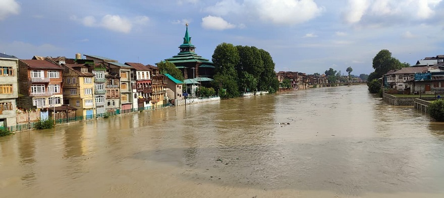
The latest spell of rain has continued for several days, causing water levels to rise in the Jhelum and some of its tributaries. At Ram Munshi Bagh in Srinagar, the river has remained above the 18-foot flood declaration mark, although it is still below the 21-foot danger level.
Officials have stressed that there is currently no immediate threat of a major flood, with the overall river trend expected to remain manageable. However, the situation continues to be closely monitored amid forecasts of another wet spell.
The concern is not simply about the water level today. For many Kashmir residents, every prolonged spell of heavy rain carries the psychological weight of 2014—a disaster that submerged large parts of Srinagar and left a deep scar on the Valley’s collective memory.
At the same time, questions are being raised about the pace of flood-management works sanctioned after the 2014 disaster. According to a recent report, ₹2,021 crore in post-2014 flood-management projects has been approved, but key components remain delayed, with technical disagreements reportedly holding up major works. The figure in the available reporting is ₹2,021 crore, rather than ₹2,022 crore.
Jhelum Above Flood Declaration Mark, But Below Danger Level
The latest readings show why authorities are maintaining heightened vigilance without declaring an immediate flood emergency.
At Ram Munshi Bagh, the Jhelum was reported at around 18.96 feet, above the flood declaration mark of 18 feet but below the danger threshold of 21 feet.
At Sangam in Anantnag, the water level was around 19.77 feet, while the Pampore gauge stood at approximately 5.09 metres in the reported readings.
The river has shown fluctuations, with some gauges recording fresh rises even after periods of recession. The official flood monitoring system also showed Ram Munshi Bagh at the warning/flood-declaration level, while conditions at other gauges varied.
Latest River Situation at a Glance
| Location | Reported Level | Situation |
|---|---|---|
| Ram Munshi Bagh, Srinagar | 18.96 ft | Above flood declaration mark; below danger level |
| Sangam, Anantnag | 19.77 ft | Below reported warning threshold |
| Pampore | 5.09 m | Water levels under close watch |
| Asham | 12.74 ft | Monitoring continues |
| Wular Lake | 1576.10 m | Closely monitored |
| Tributaries | Fluctuating | Mostly below warning levels, with temporary surges reported |
The key message from officials is clear: the river is being watched closely, but current conditions are not being treated as a repeat of the 2014 flood scenario.
Five Days of Rain Keep Kashmir on Edge
Intermittent rainfall has continued across the Valley, with several areas experiencing showers for days.
The prolonged wet spell has raised concerns in South Kashmir, where tributaries and mountain streams can respond rapidly to intense rainfall in their upper catchments.
Among the streams being watched are:
- Vishow Nallah
- Rambiyara Nallah
- Lidder Nallah
- Doodhganga
- Sindh Nallah
While many tributaries have shown signs of recession, temporary surges remain possible whenever heavy rain returns to the catchment areas.
This is particularly important because the greatest immediate risk during intense rainfall may not always come from the main Jhelum channel. Flash floods and landslides can occur in smaller streams and steep mountain catchments even when the Jhelum itself remains below its danger mark.
Why Every Heavy Rain Spell Brings Back 2014
For Kashmir, the word “flood” carries an emotional meaning that goes far beyond a weather warning.
In September 2014, catastrophic flooding struck Jammu and Kashmir after extreme rainfall. Official Government of India data recorded 282 human deaths, while more than 2.53 lakh houses were reported damaged and 6.48 lakh hectares of cropped area was affected.
Large parts of Srinagar remained submerged, disrupting homes, hospitals, businesses, transport and communications.
The disaster fundamentally changed how Kashmiris view prolonged rainfall.
Today, whenever the Jhelum rises and rain continues for several days, residents closely follow gauge readings and weather updates. The anxiety is particularly strong among those who personally experienced the 2014 catastrophe.
But experts and officials caution against drawing a direct comparison between the current situation and the 2014 disaster solely on the basis of rainfall or river levels.
The present readings remain below the danger thresholds at key gauges, and the current situation is being actively monitored.
The ₹2,021-Crore Question: How Prepared Is Kashmir?
The latest flood anxiety has also reopened a much larger question: How much has Kashmir actually strengthened its flood defences since 2014?
According to a report published on July 25, two major post-2014 flood-management programmes were sanctioned with a combined value of ₹2,021 crore.
The programmes were designed to address some of the Valley’s most critical flood vulnerabilities, including:
- Strengthening Jhelum embankments.
- Dredging and improving river capacity.
- Re-sectioning the Flood Spill Channel.
- Widening the outfall channel.
- Improving the carrying capacity of the Jhelum system.
- Strengthening flood forecasting and management infrastructure.
However, the implementation of some major components has reportedly been delayed.
The report said ₹488 crore had already been utilised, while two key components of the ₹1,623-crore Comprehensive Flood Management Programme Phase-II had yet to begin. The delayed works reportedly include re-sectioning the Flood Spill Channel and widening the outfall channel.
Technical Disagreement Becomes a Major Roadblock
The reported delays are linked to disagreements over technical specifications and design between agencies involved in the project.
According to the report, differences emerged between the Central Water and Power Research Station (CWPRS) and the consultant associated with the Jhelum Tawi Flood Recovery Project (JTFRP).
The matter was reportedly referred to the Central Water Commission (CWC), which recommended technical changes involving the Flood Spill Channel’s off-take point and the channel gradient toward Wular Lake.
The issue highlights a crucial problem in disaster management: flood protection is only as effective as the speed at which projects move from sanction to execution.
A project delayed by technical disputes may still be financially sanctioned on paper, but its protective value remains unrealised until the work is completed on the ground.
The Real Risk: A Changing Climate Meets an Incomplete Defence System
The flood debate is becoming more urgent because Kashmir’s weather patterns are also changing.
The Valley is increasingly experiencing a combination of:
- Short-duration intense rainfall.
- Cloudbursts.
- Flash floods.
- Landslides.
- Longer dry spells.
- Extreme heat.
- Unpredictable precipitation patterns.
Climate scientists have warned that a warming atmosphere can hold more moisture, potentially contributing to more intense rainfall events under favourable atmospheric conditions.
For Kashmir, the implications are particularly serious.
A sudden burst of intense rain in the upper catchments can rapidly raise tributary levels, trigger landslides and send large volumes of water downstream. This means flood resilience cannot focus only on the Jhelum itself.
It must also include the entire river basin—from mountain catchments and tributaries to urban drainage, wetlands, flood channels and the Jhelum’s outfall system.
Srinagar’s Flood Risk Is Bigger Than the Jhelum
The Valley’s flood vulnerability is not determined by one gauge station alone.
A major flood threat can emerge from a combination of:
1. Heavy Rainfall in Upper Catchments
Rain in South Kashmir’s mountainous areas can rapidly increase tributary flows.
2. Tributary Surges
Streams such as Vishow, Rambiyara and Lidder can rise quickly during intense rainfall.
3. Urban Drainage Failure
Heavy rainfall can overwhelm drainage networks even before river levels reach dangerous thresholds.
4. Saturated Soil
After several days of rain, the risk of landslides increases significantly in hilly areas.
5. Jhelum’s Carrying Capacity
The ability of the main river and flood channels to carry excess water remains central to Kashmir’s long-term flood resilience.
This is why flood management must be treated as a basin-wide environmental and engineering challenge, rather than simply a matter of monitoring the river gauge at Srinagar.
2014 Changed Kashmir’s Flood Management Strategy—But Has It Changed Enough?
After the 2014 catastrophe, flood management became one of Kashmir’s most urgent infrastructure priorities.
Authorities have since pointed to:
- Jhelum dredging.
- Embankment strengthening.
- Flood forecasting systems.
- Improved river monitoring.
- Emergency response mechanisms.
These measures have undoubtedly improved preparedness.
But the current situation raises a difficult question: Are these improvements progressing quickly enough to match the changing nature of extreme rainfall?
The answer matters because the risk landscape itself is evolving.
Infrastructure designed around historical rainfall patterns may not always provide sufficient protection against increasingly intense weather extremes.
Another Wet Spell Could Test the System Again
Weather forecasts indicate the possibility of another wet spell around July 28, keeping authorities on alert.
If rainfall remains moderate and tributaries continue to recede, the current situation may remain manageable.
However, a sudden burst of intense rainfall could quickly change conditions, particularly in South Kashmir’s upper catchments and landslide-prone mountain areas.
This is why authorities are urging residents to remain vigilant without creating unnecessary panic.
What Residents Should Do
Residents living near rivers, streams and low-lying areas should:
- Avoid unnecessary movement near riverbanks.
- Stay away from swollen streams and nallahs.
- Monitor official flood bulletins and gauge readings.
- Keep essential medicines and emergency supplies ready.
- Charge mobile phones and power banks during prolonged rainfall.
- Avoid crossing flooded roads or bridges.
- Follow evacuation instructions immediately if issued.
People travelling through mountainous areas should also remain alert to landslides and sudden road closures.
The Jammu–Srinagar National Highway and other mountain routes can be particularly vulnerable during prolonged heavy rainfall.
The Bigger Warning: Kashmir Cannot Afford to Wait for the Next 2014
The immediate message from officials is reassuring: there is no immediate major flood threat at present.
That reassurance is important—and the available river data supports the distinction between current conditions and the catastrophic levels associated with a major flood.
But reassurance should not become complacency.
The combination of rising climate variability, intense rainfall events, vulnerable mountain catchments and incomplete flood-management infrastructure demands continued attention.
The reported ₹2,021-crore flood-management programme represents a substantial investment in protecting Kashmir. But the real measure of that investment will not be the amount sanctioned—it will be the infrastructure actually completed and functioning when the next extreme rainfall event arrives.
For now, the Jhelum remains below its danger mark at the key Srinagar gauge, and authorities say there is no immediate reason for panic. But with more rain in the forecast, the Valley’s flood gauges will remain under close watch.
The lesson from 2014 is not that every prolonged rainfall spell will produce another catastrophe.
It is that Kashmir must be prepared before the water rises—not after.
Editor’s Fact-Check Note
The supplied brief cited both ₹2,022 crore and ₹2,021 crore for the flood-management initiative. Recent reporting available for this update puts the combined value of the two major post-2014 projects at ₹2,021 crore, with ₹488 crore reportedly utilised and key Phase-II components delayed amid technical disagreements. I have therefore used ₹2,021 crore throughout this updated feature to avoid propagating the conflicting figure.
The latest available river readings cited above are also time-sensitive and can change rapidly with rainfall. The 18.96-ft Ram Munshi Bagh figure, 19.77-ft Sangam reading and 5.09-metre Pampore figure reflect the reported gauge situation used for this update, not a permanent status.