Beyond Tourism: Why Aharbal Waterfall’s Geological Study Should Concern Kashmir’s Planners
By: News Desk | 09 November 2026
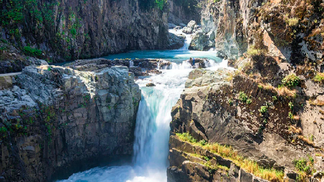
Kulgam: The spectacular waterfall at Aharbal has been changing its position for thousands of years. What appears to visitors as a permanent natural landmark is, in reality, part of a constantly evolving geological landscape.
A scientific study has now put a remarkable figure to that transformation: Aharbal Waterfall has retreated approximately 538 metres upstream over an estimated period of 57,000 years.
The finding is fascinating in itself. But the more important message lies beneath the headline.
Researchers have identified fractured volcanic rocks, nearby geological faults, unstable riverbanks and signs of gradual ground movement around the waterfall. Their findings raise concerns about possible rockfalls, landslides, river blockage and flooding, particularly if a major slope failure or earthquake affects the area.
The research does not predict that Aharbal is about to collapse. Nor does it suggest that tourists are facing an immediate disaster. It does, however, provide scientific evidence that the landscape surrounding one of south Kashmir’s best-known tourist destinations is geologically active and requires closer monitoring.
For years, Aharbal has been promoted primarily for its scenic beauty, cascading water and surrounding mountain landscape. The new research suggests that its importance goes much further.
It is also a geological archive, preserving evidence of ancient glaciers, volcanic rocks, river erosion and tectonic forces that have shaped the Pir Panjal mountains over tens of thousands of years.
For scientists, this is an important discovery. For the administration, it should become a planning priority.
The 538-Metre Retreat: What the Researchers Actually Discovered
The research, titled Climatic, Tectonic, and Fluvial Controls on the Origin and Retreat of the Aharbal Waterfall, Himalaya, was published in the international journal Results in Earth Sciences in 2025.
The study was conducted by Omar Jaan Paul, Reyaz Ahmad Dar and Shakil Ahmad Romshoo, researchers associated with the University of Kashmir and collaborating research institutions.
The authors describe their work as the first attempt to quantify the origin and retreat of a waterfall in the Himalayan region.
Their investigation combined geological fieldwork, high-resolution drone surveys, measurements of rock strength, river-discharge records and geomorphological analysis.
The findings indicate that the waterfall has migrated approximately 538 metres upstream from its original position.
The researchers calculated an estimated average retreat rate of 0.94 centimetres per year.
That translates into approximately 9.4 millimetres annually, averaged across an exceptionally long geological period.
At this rate, the researchers estimate that the waterfall took around 57,000 years to migrate from its original location to its present position.
However, there is an important scientific qualification.
The 538-metre movement is a reconstruction based on geological evidence and an empirical model. It is not a distance measured through continuous observations over 57,000 years.
The researchers reconstructed earlier positions using geological features preserved downstream, including former river falls, plunge pools and other erosion-related formations.
They then estimated the average retreat rate using a model that considers the erosive force of flowing water and the resistance of the underlying rocks.
The 57,000-year timeline is therefore a model-based estimate, not a directly dated historical record.
That distinction is essential to understanding the research accurately.
How Did a Waterfall Move More Than Half a Kilometre?
To understand the discovery, it helps to understand how waterfalls develop and change over time.
A waterfall generally forms where a river encounters a sudden change in elevation or a resistant geological structure. This creates a steep section of the river channel, commonly described by geomorphologists as a knickpoint.
At Aharbal, the process began after glacial activity shaped the landscape of the Pir Panjal region.
The researchers believe that the Vishav River initially flowed over deposits left behind by glaciers. Over time, the river eroded these relatively loose deposits, exposing the harder volcanic rocks underneath.
These rocks belong to the ancient Panjal Volcanics and include basalt and agglomeratic slate formations.
Once exposed, the underlying rocks influenced the river’s course and created the conditions for the development of the waterfall.
But these rocks are not one continuous, unbroken mass.
They contain multiple sets of joints, fractures and structural weaknesses.
Water continuously enters these openings, gradually weakening the surrounding rock. As erosion progresses, sections of the rock face become unstable.
Eventually, blocks detach under the combined influence of flowing water and gravity.
The detached material is carried downstream, while the waterfall’s steep face develops further upstream.
This process is known as waterfall retreat.
The process may be slow for long periods, but the removal of a large rock block can produce a sudden change in the position of the waterfall.
In other words, the waterfall does not necessarily move a few millimetres every year. Its movement can be episodic, with relatively stable periods interrupted by larger failures.
Fractured Basalt: The Hidden Weakness Beneath Aharbal
One of the most important findings concerns the geological structure of the rocks surrounding the waterfall.
Basalt is generally a strong volcanic rock. Under ordinary conditions, it can resist erosion better than many softer sedimentary formations.
However, the strength of a rock does not tell the entire story.
A heavily fractured rock mass can behave very differently from an intact piece of basalt.
At Aharbal, researchers identified three prominent sets of joints cutting across the underlying rocks. Their intersecting orientations create triangular and cubic blocks that can become detached through erosion and gravity-driven movement.
The study explains how flowing water removes weakened material through a process known as plucking, while larger blocks may topple away from the waterfall face.
This mechanism helps explain why the waterfall has continued to migrate upstream despite being formed in relatively resistant volcanic rocks.
The researchers also conducted approximately 500 Schmidt hammer impacts across 25 sites to assess the strength of fresh and partly weathered rocks.
Their measurements indicated average rock strengths of approximately:
- Fresh basalt and agglomeratic slate: 70.91 megapascals.
- Partly weathered rock: 65.75 megapascals.
The difference highlights how weathering reduces the resistance of exposed rock surfaces.
It also explains why the condition and orientation of fractures can be just as important as the original strength of the geological material.
The Role of Glaciers: A Landscape Shaped Before Modern Kashmir
The study also provides an interesting reconstruction of Aharbal’s ancient geological history.
Long before the waterfall became a tourist attraction, the region was shaped by extensive glacial activity.
The researchers identified features associated with ancient glaciers, including:
- Glacial striations on exposed rocks.
- Erratic boulders transported by ice.
- Roche moutonnée formations shaped by glacial erosion.
- Deposits of glacial and fluvioglacial material.
These features help establish that glaciers once extended into the Vishav River valley.
As the glaciers retreated, they left behind deposits that were subsequently eroded by flowing water.
This exposed the underlying volcanic bedrock and helped establish the geological conditions responsible for the waterfall.
The distinction between the age of the rocks and the age of the waterfall is important.
The Panjal Volcanics are hundreds of millions of years old, while the present waterfall is a much younger geomorphological feature whose formation and migration are linked to post-glacial landscape evolution.
The study therefore connects two very different chapters of Kashmir’s geological history: ancient volcanic activity and relatively recent glacial and river processes.
The Most Serious Finding: Signs of Geological Instability Around the Waterfall
While the 538-metre retreat has attracted attention, the researchers’ observations concerning the surrounding slopes deserve even greater scrutiny.
During their field investigations, they identified several features suggesting ground movement and structural weakness around the Aharbal stretch of the Vishav River.
These included:
1. Road subsidence
Researchers observed signs of subsidence along a road near the waterfall. Ground movement can damage road surfaces and indicate instability in the underlying material.
2. Displaced retaining walls
Some retaining walls showed displacement, with observations suggesting movement towards the waterfall.
This is significant because retaining structures are generally intended to stabilise slopes and protect nearby infrastructure.
3. Rock fractures and shearing
The researchers identified highly fractured and sheared rock formations along the riverbanks, including areas associated with nearby geological faults.
4. Signs of gradual ground creep
The study also documented trees with unusually bent, pistol-shaped trunks. Such growth patterns can sometimes indicate slow movement of the ground supporting their roots.
5. A landslide near the river
A landslide was observed along the left bank of the Vishav River near the waterfall, close to an inferred fault trace.
The researchers treated this as evidence of local geomorphic instability, while cautioning that a landslide alone does not establish active fault movement.
Taken together, these observations indicate that the surrounding landscape deserves detailed geotechnical examination.
They also suggest that the risk assessment should not focus exclusively on the waterfall itself. The stability of the riverbanks, roads, retaining structures and adjoining slopes is equally important.
Is Aharbal Situated on an Active Geological Fault?
This is an important point that requires careful explanation.
The study identifies nearby faults and tectonic structures as contributing factors in the geological evolution and instability of the Aharbal region.
It also identifies a fault crossing the Vishav River a few metres upstream of the present waterfall, with evidence of sheared rocks and structural weaknesses along the riverbanks.
However, the researchers make an important distinction: the present waterfall was not formed directly by faulting.
According to their interpretation, its development was primarily driven by the erosion of glacial deposits and the exposure of highly jointed basaltic bedrock.
No fault was identified intersecting the present waterfall lip itself.
This means the geological concern is not that the waterfall sits directly on a fault that is about to rupture.
Rather, the concern is that the surrounding terrain contains a combination of tectonic structures, fractured rocks and unstable slopes that could become more vulnerable under certain conditions.
Earthquake-related ground shaking, for example, could weaken already fractured rock masses. Water entering existing cracks may further reduce the resistance of some blocks, potentially triggering rockfalls or larger slope failures.
The study identifies these as potential hazards, not as events that have been forecast for a particular date.
Could a Landslide Block the Vishav River?
Perhaps the most consequential scenario discussed in the research involves the possibility of a major slope failure blocking the river.
The Vishav River is not a small stream confined to the immediate waterfall area. It is a major watercourse draining a catchment of approximately 1,060 square kilometres and ultimately joining the Jhelum near Sangam.
A substantial landslide entering the river could temporarily obstruct its natural flow.
If enough water accumulated behind the obstruction, a temporary lake or backwater could develop.
Should the natural barrier subsequently fail, the accumulated water could be released suddenly, creating downstream flooding.
This type of event is commonly associated with landslide-dammed rivers and, in severe circumstances, outburst floods.
The study also identifies possible changes in river flow and accelerated erosion as consequences of major slope instability.
It is important not to confuse a possible hazard scenario with a prediction.
The researchers have not established that a river-blocking landslide is imminent, nor have they provided a probability or timeline for such an event.
But the possibility is serious enough to justify identifying vulnerable slopes, monitoring riverbanks and preparing an emergency response plan.
For authorities, the question should be whether the area has adequate arrangements to detect significant ground movement and respond before a potentially dangerous situation develops.
A Wider Environmental Problem: The Vishav River Is Already Under Scrutiny
The geological study becomes even more relevant when considered alongside separate environmental concerns affecting the wider Vishav River system.
In January 2025, the National Green Tribunal took suo motu cognisance of a news report concerning pollution and alleged unregulated mining in the Vishav stream.
The matter was registered as Original Application No. 1391/2024 following a report published by Greater Kashmir in December 2024.
The tribunal sought responses from the Jammu and Kashmir Pollution Control Committee, the Central Pollution Control Board and other concerned authorities.
Subsequent inspections by the J&K Pollution Control Committee on February 20 and March 8, 2025, produced findings that deserve attention.
According to the inspection report included in the CPCB’s submission to the NGT, 19 mineral blocks were operating along the Vishav River in Kulgam district.
Of these, 11 were reported to be operating without valid consent to operate under the Air and Water pollution-control laws.
Inspectors also recorded the use of JCB machines, tippers and tractors for extracting boulders and other material. They noted that demarcation boundaries had not been provided in the inspected leased mining areas.
The report further documented heaps of extracted material and pits in riverbeds, with observations that these were disrupting the natural movement of water and altering its course at several locations.
These findings raise important questions about the management of the river system.
However, the water-quality results also require balanced reporting.
Samples collected at seven locations were found to meet the prescribed physicochemical standards for organised outdoor bathing. At the same time, three locations did not meet the desirable faecal-coliform limit, and the report identified comparatively poorer water quality in downstream locations, attributing this potentially to agricultural runoff, untreated wastewater and solid waste.
The findings therefore do not support the simplistic conclusion that the entire river is polluted beyond permissible limits. They do establish that environmental pressures and regulatory concerns exist along the wider river system.
There is another important distinction: these mining-related findings concern the Vishav river system in Kulgam and should not be presented as proof that mining caused the waterfall’s 538-metre retreat or that all 11 blocks are situated immediately beside the waterfall.
The geological study and the pollution-control inspection address different problems.
But both point towards the need for better management of the same river basin.
A river cannot be managed effectively by examining only its most photographed section.
Tourism Development Must Recognise Geological Risk
Aharbal is officially recognised as one of Kulgam’s major tourist attractions.
The district administration describes it as the Niagara Falls of Kashmir, highlighting its dramatic water flow, natural surroundings, fishing opportunities and trekking potential.
The Jammu and Kashmir Tourism Department also promotes the destination for its waterfall, surrounding forests and adventure-tourism opportunities.
This tourism appeal creates economic opportunities for local residents, including transport operators, shopkeepers, guides and people associated with hospitality services.
But tourism infrastructure must be developed with an understanding of the physical landscape.
The study identifies weaknesses in the riverbanks and surrounding slopes, some of which are close to existing infrastructure.
That makes the location and design of visitor facilities important.
Viewpoints, walking paths, retaining walls, parking areas and access roads should not be planned solely around scenic visibility or visitor convenience. Their location must also be assessed against slope stability, rockfall exposure, drainage and possible flood hazards.
The official tourism website notes that the terraces leading to the waterfall are fenced and advises visitors to take care because of slippery conditions.
That is useful basic safety information, but the new research raises a broader question: are visitor areas also being assessed against the geological hazards identified by scientists?
A general warning about slippery paths cannot replace a proper geotechnical risk assessment.
The authorities should identify potentially vulnerable locations, map areas exposed to falling rocks or slope movement and establish clear procedures for restricting access when conditions deteriorate.
Such precautions would protect visitors without unnecessarily discouraging tourism.
Aharbal Has Already Been Recognised as a Geoheritage Site
There is another development that deserves attention.
In February 2025, a meeting chaired by Deputy Commissioner Kulgam Athar Aamir Khan reportedly reviewed the preservation of the Panjal Trap geological heritage site at Aharbal.
The meeting included representatives of the Geological Survey of India and district officials.
According to the report, GSI representatives discussed the geological significance of the Panjal Trap, volcanic rocks formed approximately 280 to 255 million years ago. The Deputy Commissioner directed the concerned revenue officer to identify a suitable location for installing a geoheritage signboard developed by GSI.
This was an important step towards recognising Aharbal’s geological value beyond tourism.
However, geological interpretation and geological risk management are two different responsibilities.
A signboard can explain the history of volcanic rocks, glaciation and waterfall formation. It cannot identify an unstable slope, measure ground displacement or provide advance warning of a potential landslide.
The new study offers an opportunity to connect these two priorities.
Aharbal should be developed as a place where visitors can understand Kashmir’s geological history while the authorities simultaneously protect them from identified natural hazards.
Interestingly, the researchers also acknowledged the Aharbal Development Authority for financial and logistical support during fieldwork.
This establishes an important institutional link between the research and the local tourism administration. The scientific findings should now be translated into practical management measures.
Climate Change: Is It Accelerating Aharbal’s Retreat?
The research title includes climatic, tectonic and fluvial controls, which naturally raises questions about climate change.
The relationship between climate and mountain landscapes is important.
Changes in rainfall, snowfall, snowmelt and river discharge can influence erosion, sediment movement and slope stability. Heavy precipitation can increase runoff, while water entering fractures can contribute to rock weakening. Freeze-thaw processes can also influence the breakdown of exposed rocks in suitable conditions.
The Himalayan region is particularly sensitive to changes in temperature and precipitation because glaciers, snow cover, rivers and mountain slopes are closely interconnected.
However, an important distinction must be maintained.
The Aharbal study does not establish that human-induced climate change caused the 538-metre retreat. Nor does it quantify how much future climate change will accelerate the waterfall’s movement.
Its findings primarily concern long-term interactions between river erosion, bedrock structure, geological uplift and post-glacial landscape evolution.
Climate change is a relevant subject for future research and monitoring, but it should not be presented as a proven explanation for the specific retreat figure.
A longer monitoring programme combining river discharge, rainfall, temperature, slope movement and repeat drone surveys could help researchers understand whether recent environmental changes are altering the rate of erosion.
The Scientific Limitation That Must Not Be Overlooked
The 0.94-centimetre annual retreat figure is striking, but its scientific meaning needs to be understood.
The researchers used an empirical model originally developed by Hayakawa and Matsukura. It estimates waterfall retreat through the relationship between the erosive force of flowing water and the resistance of the underlying rock.
For the Aharbal investigation, the researchers used 43 years of river-discharge data.
The recorded annual discharge ranged from 7.34 to 63.24 cubic metres per second, with an average of 23.32 cubic metres per second.
They also used measurements of the waterfall’s geometry, rock strength and field observations.
A high-resolution drone survey carried out in 2021 measured the waterfall’s lip at approximately 7.01 metres in width and 7.62 metres in height.
The researchers then combined these observations with geological evidence of former waterfall positions to estimate the long-term migration rate.
Their own discussion acknowledges that retreat may have varied considerably between different stages.
Large blocks can remain stable for extended periods before suddenly detaching. Such an event may produce more retreat in a short period than ordinary erosion would achieve over many years.
Consequently, the average rate should not be used to predict that the waterfall will move another 9.4 millimetres next year.
Nor should it be used to calculate an exact date when the waterfall will disappear.
There is also a difference between the study’s measurement of the main waterfall lip and the district administration’s tourism description, which refers to a 25-metre fall. These figures may use different measurement points or refer to different sections of the cascade. A standardised technical measurement would help avoid confusion in future scientific and tourism publications.
The most valuable aspect of the research is not its ability to predict an exact future movement. It is the geological evidence it provides about the landscape’s structure and potential instability.
What Should the Government Do Now?
The findings deserve a coordinated response involving the district administration, Aharbal Development Authority, Geological Survey of India, disaster-management agencies and relevant engineering departments.
Several practical measures should be considered.
1. Conduct a detailed geotechnical investigation
The entire waterfall zone and adjoining riverbanks should be assessed to identify fractured rock masses, unstable slopes, potential landslide locations and vulnerable infrastructure.
2. Establish continuous slope monitoring
Where experts identify critical locations, monitoring instruments and repeat drone or other high-resolution surveys could be used to detect ground movement, expanding fractures and changes in retaining structures.
3. Prepare a geological hazard map
The authorities should identify areas exposed to rockfall, slope failure, possible river blockage and flooding. Visitor facilities and future construction should be planned around the findings.
4. Inspect existing infrastructure
Roads, retaining walls, pathways, fencing and viewing platforms near the waterfall should undergo periodic structural and geotechnical inspections.
5. Introduce a visitor-safety protocol
Clear warning signs, restricted-access areas and temporary closure procedures should be established for locations where experts identify unacceptable risks, particularly during heavy rainfall, high river discharge or significant slope movement.
6. Monitor the Vishav River basin
Mining activity, riverbed extraction, water quality and changes in natural drainage should be monitored in coordination with the Pollution Control Committee and mining authorities.
7. Develop a geoheritage conservation plan
Aharbal should be recognised not only as a tourist destination but also as an important geological site. Scientific interpretation, conservation, visitor education and safety planning should be integrated.
These measures would help turn an important research finding into a practical public-safety and environmental programme.
Why Aharbal’s Geological Story Matters to All of Kashmir
The significance of the study extends beyond one waterfall.
The Pir Panjal region is part of the larger Himalayan system, where tectonic forces, glacial history, river erosion and changing climatic conditions have continuously shaped the landscape.
Kashmir’s mountains, valleys, rivers and lakes are not static geographical features. They are the visible outcome of processes that continue beneath and around them.
Aharbal provides an unusually clear example of these processes.
Its exposed volcanic rocks preserve evidence of ancient geological activity. Its river terraces and glacial features reveal the influence of former ice sheets. Its fractured bedrock and retreating waterfall demonstrate how water and gravity continue to reshape the landscape.
This makes the site valuable not only for tourism but also for scientific research, geological education and future environmental planning.
Recent research into Kashmir’s wider geoheritage has also highlighted the region’s potential for scientific tourism, where visitors learn about geological formations, glacial landscapes and the natural history of the Himalayas.
But geotourism cannot succeed without conservation.
If the geological features that make a destination unique are damaged through poorly planned construction, uncontrolled extraction or inadequate protection, the region risks losing an important natural asset.
The objective should be to make scientific knowledge part of tourism development rather than treating it as an academic exercise separate from everyday administration.
Conclusion: Aharbal Needs More Than Promotion. It Needs Protection.
The discovery that Aharbal Waterfall has migrated approximately 538 metres over an estimated 57,000 years is a remarkable contribution to the understanding of Kashmir’s geological history.
But the most important message is not about how far the waterfall has moved.
It is about what researchers have found around it: fractured rocks, nearby faults, unstable slopes, displaced retaining walls, signs of ground movement and the possibility of landslides affecting the Vishav River.
These observations do not mean that disaster is imminent. They do mean that ignoring the geological condition of the area would be irresponsible.
Aharbal should not have to experience a major landslide, infrastructure failure or river blockage before the authorities begin taking the findings seriously.
The administration already has a scientific foundation on which to act. What is needed now is a detailed hazard assessment, regular monitoring, responsible tourism planning and coordination between the agencies responsible for the river, slopes and visitor infrastructure.
There is also an opportunity to give Aharbal a larger identity.
It can remain one of Kashmir’s most beautiful tourist destinations while becoming an important centre for understanding Himalayan geology and environmental change.
The waterfall took tens of thousands of years to reach its present position. Its surroundings, however, cannot be left to chance.
For Kashmir, the lesson is simple: protecting a natural attraction begins with understanding the forces that shape it. And sometimes, the greatest warning is not what nature has already changed, but what its changing landscape could mean for the future.