Gone with the White Wind: Melting Mountains Paint a Grim Picture for Spring Runoff
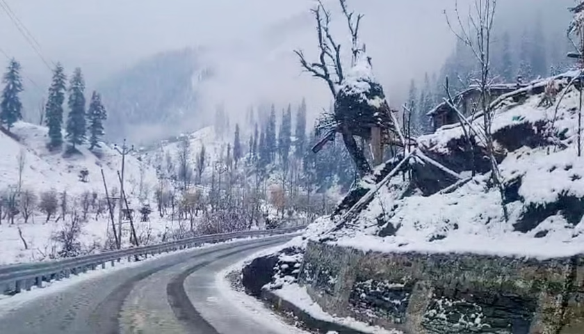
Dry, snowless peaks have cast a shadow on tourism in Kashmir and Himachal Pradesh but the impact of the underlying causes on the next few months is far more worrying — for they could portend a warmer spring.
The absence of active western disturbances and shortage of rain and snow will have implications for the Rabi (winter) crop and are suggestive of high temperatures early in spring, experts said.
In December, the rain deficiency was 79% over Jammu and Kashmir, 85% over Himachal Pradesh, 75% over Uttarakhand, and 70% over Punjab.
And thus far in January, there has been no rainfall over Jammu and Kashmir, Himachal Pradesh, Punjab, West Rajasthan and Haryana, Chandigarh, Delhi region, according to data from the India Meteorological Department. There has been hardly any snowfall in the upper reaches of Jammu and Kashmir, Uttarakhand and Himachal Pradesh which normally see a boom in tourism following snowfall. The absence of snow cover over mountains also means the hills ad plains will absorb more heat, possibly leading to an early onset of summer like temperatures, the experts added.
“Western disturbances have been very few this season,” said DS Pai, senior scientist at IMD, referring to cyclonic systems originating over the Mediterranean. “There has been below normal rainfall activity over the northern-most parts of the country. If there is no system to produce precipitation then snowfall will not happen. When there is snow cover, it helps in reflecting back the solar radiation, but if there is no snow cover, heating is expected to be more during spring.”
Typically, December and January sees at least one 1-2 western disturbances. “Snowfall has a direct relation with western disturbances during winter months. There has been no active western disturbance since December. There has been no cold wave this season except in isolated stations . We are not expecting any active western disturbance in the coming days also. Wind direction is variable and there is low level moisture; wind speed is also low. This is leading to dense to very dense fog over several parts of northwest India. Day temperatures have fallen and that is mainly because of the large fog patch covering many parts of Indo-Gangetic Plains. There is less solar radiation during the day,” explained Naresh Kumar, also a senior scientist with IMD.
There is no clarity on why there have been no western disturbances, but the climate crisis may be to blame. “Some research papers are indicating that the frequency of western disturbances over the Western Himalayas is decreasing in recent years and hence snowfall is also decreasing . The frequency of western disturbances decreasing is also an effect of climate change,” explained M Rajeevan, former secretary, ministry of earth sciences.
“We are seeing that tropical systems have moved north, they are moving more toward polar regions, this is mainly because mid latitude and polar regions are warming up. Western Disturbance is nothing but mid latitude jet stream instability. But in recent years, it is moving northward and not penetrating towards the plains of northwest India as much as it used to. Less snow in winter months has implications for the hydrological cycle and agriculture and of course early heating,” he added.
Both 2022 and 2023 saw only a fleeting spring season over most of India because of the early onset of summer-like conditions in March. A spring heatwave in 2022 led to at least 90 deaths across India and adjacent Pakistan, triggered a glacial lake burst in northern Pakistan, and led to forest fires in the hills of Uttarakhand. March 2022 eventually had the highest-ever average temperature recorded nationally. with the heat also affecting India’s wheat output.
HT reported on January 9 that 2023 was the warmest year ever, overtaking the last record set in 2016 by a large margin according to Copernicus Climate Change Service. The year was 0.60°C warmer than the 1991-2020 average, and 1.48°C warmer than the 1850-1900 pre-industrial average, barely below the 1.5°C limit the world is hoping to stay within in the 2015 Paris climate accord to avoid the most severe effects of the crisis.
Six leading international datasets used for monitoring global temperatures and consolidated by WMO show that the annual average global temperature was 1.45 ± 0.12 °C above pre-industrial levels (1850-1900) in 2023. Global temperatures in every month between June and December set new monthly records. July and August were the two hottest months on record, World Meteorological Organisation said on Friday.
“The shift from cooling La Niña to warming El Niño by the middle of 2023 is clearly reflected in the rise in temperature from last year. Given that El Niño usually has the biggest impact on global temperatures after it peaks, 2024 could be even hotter,” said Celeste Saulo, WMO secretary general.
“We expect the current El Nino to peak this month or next but there is a lag in impact on current temperatures. The first quarter of 2024 will likely continue the trend of the past year in terms of temperatures. For ocean temperatures, they are likely to continue to increase till March. Though we can expect that impacts of El Nino will dissipate later this year, we are uncertain how ocean temperatures will evolve,” Samantha Burgess, deputy director of the Copernicus Climate Change Service (C3S) said on January 9.
The continuous absence of active western disturbances is unusual experts said. “The only snowfall that has taken place is in the very upper reaches but not other areas where it is normally expected to snow. During last year’s new year eve there was an active western disturbance and widespread snowfall activity, yet spring was very warm. No active western disturbance has impacted northwest India yet. We have to see if any active western disturbances bring rain during end of January or February,” said Mahesh Palawat, vice president, climate and meteorology, Skymet Weather.
“Normally in El Nino years, the northeast monsoon is very active and southwest monsoon is weak. But we cannot also make a direct correlation with El Nino and less snowfall during winter. If this trend continues for a few more years we can conclude that this is due to climate change,” Palawat added.