On the eve of India hosting the G20 summit in New Delhi, China released a so-called “standard map” coopting parts of eastern Ladakh as per the rejected 1959 line and Arunachal Pradesh in the Middle Kingdom apart from Taiwan and the South China Sea.
This cartographic expansion by Beijing duly amplified by Chinese propaganda through social media was immediately rebutted and rejected by the Modi government as Arunachal Pradesh is an integral part of India and parts of Aksai Chin were occupied by Mao’s China in the 1950s even before the disastrous 1962 war. While India was signing the Panchsheel Agreement in 1954, China was building a highway linking occupied Tibet with occupied Sinkiang (called Xinjiang) through Aksai Chin with the then government rather oblivious to the facts.
The timing of the release of the map by China clearly has ominous portends as it poses serious questions on whether President Xi Jinping is inclined to attend the G20 summit in the Indian capital or has other plans. We are told that China releases the standard map every year but it is the first time that India has lodged a serious protest with Beijing, rejecting the territorial claims of the Middle Kingdom.
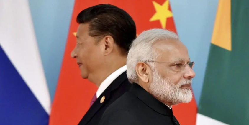
The larger question is why did Beijing release the so-called standard map and get it amplified by its propaganda media through social media platforms ? The answer lies in the recently concluded BRICS summit in Johannesburg, where Prime Minister Narendra Modi had a brief interaction with President Xi Jinping at the leaders’ lounge of the summit. It is understood that China wanted a bilateral meeting with India on the sidelines of the summit and push for normalization of ties without conceding an inch on the pending problems of Depsang Bulge and Demchok in Eastern Ladakh. Given the schedule restraints of PM Modi, the formal meeting between the two leaders could not take place and was limited to a brief interaction only. Even during the brief interaction, PM Modi raised his concerns over the border issue, clearly indicating that the road to normalization of ties goes through disengagement and de-escalation on the East Ladakh border and resolution of the remaining two friction points.
It is evident that President Xi Jinping is miffed with Prime Minister Modi’s unambiguous response that normal ties can only resume after PLA withdraws its forces from occupied Aksai Chin and that Indian Army’s patrolling rights are restored in Depsang Bulge and in CNN junction in Demchok. It is not very difficult to presume that China released the so-called standard map to teach India a lesson. It is another matter that the Modi government has totally rejected the Chinese territorial claims.
By deliberately releasing the so-called standard map on the eve of G20, China has clearly indicated that it treats India as an adversary and will put coercive pressure on India for having close ties with the US and Quad powers. This means that China will keep the military pressure up all along the 3488 km LAC and also arm its tributary state Pakistan to put pressure on India’s western borders. With the PLA throwing both the 1993 and 1996 bilateral peace and tranquility agreements into dustbin by May 2020 transgressions in East Ladakh, India has to be prepared for the worst with China as Modi’s India has bigger ambitions than playing second fiddle to Communist China by becoming a regional power. India will respond to Chinese cartographical expansion in time.
#XiJinping, #India, #G20Summit, #mapcontroversy, #ArunachalPradesh, #China, #borderdispute, #territorialclaims