Why next biggest earthquake in Himalayas could be triggered by Indians
By: CP Rajendran & Kusala Rajendran
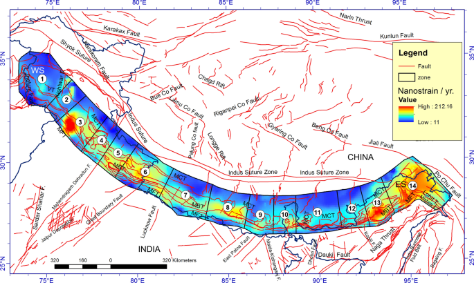
The Himalayas produced three great earthquakes in the last century alone—1905, 1934 and 1950, but none afterwards. With increasing clarity on the nature of temporal-spatial patterns of earthquakes, there is a consensus about the identifiable gaps along the Himalayas.
The central Himalayas are recognised as one such gap, primed for a future large or great earthquake. The long interval of at least 500 years marked by the absence of earthquakes represents a period of missing slip which amounts to the absence of earthquakes that help de-stress the region. A moderate earthquake here or there, like the 1991 Uttarkashi and 1999 Chamoli, is not enough to release the accumulated stresses in the Himalayas. Even the 2015 Nepal earthquake has left the gap unfilled.
The notable historical example of an earthquake from the central Himalayas is the 1803 event in the magnitude range of 7.5. This earthquake not only struck the mountainous regions but also affected far-off locations.
It triggered landslides that smothered villages up in the hills, generated distant soil liquefaction, and amplified acceleration in the Ganga alluvial plains. The upper story of the Qutb Minar toppled during that earthquake.
Similarly, if an earthquake of magnitude 7.8, like the 1905 Kangra event, were to happen today, the estimated direct losses would be more than 100 billion rupees. More than a hundred thousand lives would be lost. However, if earthquake-resistant provisions are provided for the constructions, the direct losses from ground shaking could be reduced to one-fifth.
Such big earthquakes pose serious threats to our monuments in various parts of the Gangetic plain. And Delhi requires special mention as the capital, with many heritage structures, monuments and government buildings.
The north-east Himalayas—an area that witnessed great earthquakes in 1897 and 1950—also hosts such gaps. Further north, the Tibetan region has seen major earthquakes with devastating impacts on the landscape brought about by the earthquake-triggered landslides and flooding. One of the biggest threats in the north-east Himalayas would be landslip-impounded dams and consequent flooding of the downstream sides.
The 1950 earthquake of magnitude 8.6 located just south of the McMahon line, the boundary between India and China, dammed the rivers. The dams were breached later, generating flash floods on the downstream sides, and seriously silting the river basins. If a similar event were to take place in the background of the fast-developing super hydro-projects, it would be an unimaginable replay of past destructions.
Back in 1950, the vast flood plains of Brahmaputra accommodated the debris. Should it happen in the future, the heavy siltation and giant landslides will severely reduce the water-holding capacity and life expectancy of such dams.
The Last Straw on the Camel’s Back
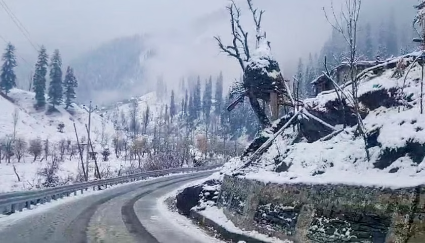
Images from the Himalayas, showing a hectic construction spree, are disconcerting not just from the point of environmental sustainability but also from the point of earthquake response. The unique Himalayan landscape with steep slopes and sharp gradients is not inherently amenable to human engineering as it is dynamically heterogeneous in various natural processes.
Human-induced changes to these naturally regulated environmental conditions will likely tip the balance, triggering diverse secondary effects like landslides and rockfalls. Take, for example, the Char Dham project, a road-widening undertaking in the Himalayas. The 900 km long, two-lane highway designed to improve the connectivity to the Char Dham Hindu shrines (Badrinath, Kedarnath, Gangotri and Yamunotri) is deeply worrying from the point of disaster response and mitigation.
Due to deforestation and road building, the steep slopes of soft rocks are bound to slide. The proposed 8 m wide freeway will not stand the rigours of landslides, floods and earthquakes, and the secondary effects could be equally severe if not more. The threat is grave when constructions occur in active seismic zones, which may also coincide with areas of high population density.
For example, the recent rapid subsidence reported from the hill town of Joshimath has variously been attributed to hasty urbanisation, infrastructure and hydropower projects destabilising the terrain. We must remember that the Himalayan states’ population increased 1.5 times between 1971 and 2021. At the same time, there is a three-fold rise in population density due to the changing land use and rapid urbanisation in these states.
Another noteworthy point is the non-viability of ‘super’ dam projects in the Himalayas. Over the past twenty years, China and India have been competing to build massive hydroelectric projects in these areas, which are ecologically sensitive and prone to earthquakes. There are two hydropower projects in plan in Arunachal Pradesh on the tributaries of the Brahmaputra. These are the 600-megawatt (MW) Kameng project on the Bichon and Tenga Rivers and the 2000 MW Subansiri Lower Hydroelectric Project.
Across the border, China has already completed eleven out of fifty-five projects that are planned for the Tibetan region. There are about eighty-one large hydropower projects in the unstable Himalayan region on the Indian side (that includes sites in Jammu and Kashmir, Himachal Pradesh, Uttarakhand, Sikkim and Arunachal Pradesh), with another twenty-six reportedly under construction. An alarming 320 additional projects are in the pipeline. These activities are likely to alter the hydrological conditions of the region. From an earthquake hazard point of view, the triggering of earthquakes due to reservoir-induced hydro-mechanical stresses cannot be ruled out.
The disaster that struck Sikkim in the early hours of Wednesday, 4 October 2023, was an eye-opener. An intense surge of floodwaters flowed into the Teesta River in Lachen Valley, washing away several bridges and roads and ramming the Teesta-III Dam in Chungthang in Sikkim, causing part of it to give away. According to the statement issued by the National Disaster Management Authority of India, the flash flood was the result of a cloudburst causing the Lhonak glacial lake, located at 5,200 metres above sea level, to overflow the impounding moraine, eventually eroding it to form an outlet.
A glacial lake outburst usually results in more damage and destruction than a flood caused by excess rainfall alone. The incidents of glacial lake outbursts are on the increase in the Himalayas, primarily owing to the upward trend in global warming.
It is worth remembering that on 7 February 2021, a similar catastrophic mass flow descended the Rishiganga and Dhauliganga valleys in Chamoli, Uttarakhand, killing more than 200 people and damaging two hydropower projects. The 2013 Kedarnath disaster was another devastating example of a glacial lake outburst caused by the overflowing glacial lake up in the mountain, resulting in 6000 fatalities.
The tragedy that occurred on 22 March 1959, at Vajont Dam, 100 km north of Venice in Italy is an international example that reminds us of the potential threat of such massive, engineered structures in landslide-prone areas. During the initial filling of this 262 m high dam, a landslide caused a mega-tsunami in the lake. The wave of 250 m (820 ft) that formed after overflow in the lake brought massive flooding and destruction to the valley below.
In executing hydroelectric projects in the Himalayas at a maddening pace, the two countries, China and India, overestimate their economic potential. The planners grossly underestimate the loss due to potential environmental hazards, including earthquakes and glacial lake outbursts.
If a massive earthquake occurs in this region, the consequent landslips could flood the dam. The recent Sikkim event compels us to step back and reassess the dangers inherent in building massive dams in the Himalayas. The Himalayas require special attention in terms of the potential for earthquakes as well as flood disasters.
A special effort needs to be mounted to develop hazard scenarios and models as well as land-zonation maps that demarcate areas prone to floods and landslides. There should also be serious rethinking of the developmental models for the Himalayan states in the context of climate change and the earthquake potential, while also bringing the major stakeholders—the people on board for their feedback and active participation in environmental conservation.
Like any natural process, earthquakes are bound to happen. But the aftermath would depend on our preparedness. Modern and advanced economies are better prepared unless caught entirely off-guard. India must learn from the experiences of countries like Chile, where investment in resilient infrastructure, early warning systems and urban planning have enabled them to survive a massive earthquake with minimum loss.