Pakistan on Tuesday raised its objections to a draft bill prepared by the Narendra Modi government which strictly prohibits wrong depiction of Jammu and Kashmir and Arunachal Pradesh as non-Indian territories.
Expressing its “serious concern” to the United Nation over the draft bill introduced in the Indian Parliament over the map of Kashmir, Pakistan called upon the world body to uphold its resolutions and urge India to stop such acts which are in “violation of international law“.
“Pakistan has expressed serious concern to the United Nations Secretary General and the President of the UN Security Council, through letters by our Permanent Representative in New York, with regard to the Indian government’s efforts to introduce a controversial ‘Geospatial Information Regulation Bill’ in the Indian Parliament,” the Foreign Office (FO) said.
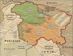
It further said that “in violation of UNSC resolutions, the official map of India has been depicting the disputed territory of Jammu and Kashmir as part of India, which is factually incorrect and legally untenable”.
Through the passage of this Bill, the Indian government would penalise the individuals and organisations who depict Jammu and Kashmir as a disputed territory as per the United Nations Security Council (UNSC) resolutions, the FO said.
“The letter calls upon the United Nations to uphold the UNSC resolutions and urge India to stop such acts which are in violation of international law,” the FO said.
“We have urged the international community and the United Nations to fulfill their commitment with the people of Jammu and Kashmir by holding an independent and impartial plebiscite under UN auspices,” it said.
The Modi government had prepared the ‘The Geospatial Information Regulation Bill 2016’ following instances where certain social networking sites showed Jammu and Kashmir and Arunachal Pradesh as part of Pakistan and China respectively.
The bill prohibits showing parts of India as territories of China or Pakistan on any digital platform and could land violators in jail with a maximum term of seven years and fine up to Rs100 crore.
If the Bill becomes a legislation, online platforms like Google will have to apply for a licence to run Google Maps or Google Earth in India.
According to the proposed law, it will be mandatory to take permission from a government authority before acquiring, disseminating, publishing or distributing any geospatial information of India.
The Bill says those who already have this information will be required to make an application for a license within one year of the law coming into existence.
No person shall depict, disseminate, publish or distribute any wrong or false topographic information of India including international boundaries through internet platforms or online services or in any electronic or physical form, the bill says.
Whoever, if any geospatial information of India in contravention of the law is acquired, it shall be punished with a fine ranging from Rs1 crore to Rs100 crore and/or imprisonment for a period upto seven years, according to the draft Bill.
Meanwhile responding to Pakistan’s expression of concern to the United Nations over the depiction of Jammu and Kashmir in India’s draft geospatial information bill, the External Affairs Ministry (MEA) on Tuesday said that the proposed (map) bill is an entirely internal legislative matter of India and that neither Pakistan nor any other party has locus standi on the matter.
“The proposed bill is an entirely legislative matter of India since the whole state of Jammu and Kashmir is an integral part of India. Pakistan or any other party has no locus standi on that matter,” MEA spokesperson Vikas Swarup said.
“The government firmly rejects repeated and increasing attempt to impose on the international community matters that India has always been open to address bilaterally with Pakistan,” he added.
Pakistan expresses concern to UN over bill on Kashmir map