Tangmarg–Poonch Road: A Lifeline Alternative for Kashmir’s Fragile Highway
By: Javid Amin | 11 October 2025
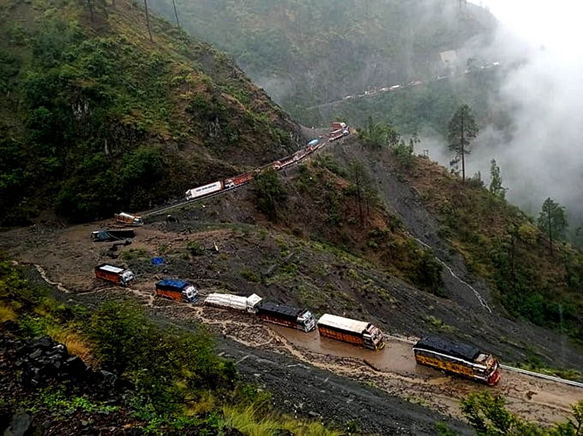
For years, the Srinagar–Jammu national highway (NH-44) has borne the weight of connecting the Kashmir Valley to the rest of India. But nature, terrain, and congestion often conspire against it: landslides, heavy snowfall, rockfalls, and accidents frequently force closures. In this fragile corridor, alternatives have been discussed, proposed, delayed — until recently.
Enter the Tangmarg–Poonch Road — a long-awaited project, now sanctioned under the Union Defence Ministry and to be executed by the Border Roads Organisation (BRO). Its ambition: to link Tangmarg in North Kashmir with Poonch in the Pir Panjal region, creating a bypass that sidesteps some of the most volatile stretches of NH-44. If realized fully and thoughtfully, this route could transform movement, trade, and connectivity in the region.
But the path from sanction to impact is fraught with technical, environmental, social, and political challenges. This article examines:
-
The vulnerability of the current Srinagar–Jammu highway
-
Why Tangmarg–Poonch holds strategic value
-
Project design, status, and route dynamics
-
Socioeconomic opportunities and hopes
-
Risks, trade-offs, and mitigation needs
-
Political dynamics, stakeholder voices, and roadblocks
-
A roadmap ahead and key caveats
Let’s begin by laying out the case: why the Srinagar–Jammu highway is so vulnerable, and how this new road might relieve that pressure.
1. The Vulnerability of the Srinagar–Jammu Highway
The Srinagar–Jammu highway, often called NH-44 (formerly NH-1A in parts), is more than just a major road: it is the lifeline for people, goods, medicines, food, and essential services between the Kashmir Valley and the rest of India. But its geography imposes relentless stress.
1.1. Terrain, climate, and disaster risks
-
The highway traverses treacherous terrain: steep slopes, narrow gorges, fragile hillsides, and zones prone to rockfall and landslides.
-
During the monsoon season, heavy rains trigger slope instability and water seepage, causing landslides or road collapses.
-
In winter, snow accumulation and avalanches block routes, particularly near high passes.
-
The stretch between Ramban and Banihal is especially notorious as a disaster hotspot. As one recent report put it: “the stretch between Ramban and Banihal … is a cause for grave concern” due to frequent landslides and closures.
-
Even in “normal” times, the highway suffers from bottlenecks, narrow curves, traffic congestion, and maintenance deficits.
1.2. Frequent closures, stranded traffic, and economic losses
-
Every closure disrupts supply lines: essential goods, medicines, fuel, and daily consumables get delayed or blocked.
-
Commerce and trade between the Valley and Jammu, and further to national markets, suffer cost escalations, spoilage of perishable goods, and opportunity losses.
-
Passengers are stranded, emergency services delayed, and medical transfers impeded.
-
The psychological stress is real — for frequent travelers, the uncertainty of passage is a daily burden.
Thus, the congestion and unpredictability of NH-44 make even short journeys fraught with risk, delay, and cost.
1.3. Previous attempts and complementary routes
Over time, several alternatives or complementary routes have been proposed and developed to alleviate pressure:
-
Banihal–Qazigund Tunnel: The 8.45 km twin-tube tunnel, opened in 2021, has helped bypass the older Jawahar Tunnel and shortened travel time between Jammu and Srinagar.
-
Mughal Road (Shopian ↔ Poonch route): This historic route cuts across Pir Panjal, connecting Poonch to Shopian (~84 km). It is partly seasonal.
-
Recently, the government approved a tunnel on the Mughal Road to make it an all-weather alternative to NH-44. This approval underscores the urgency of diversifying routes.
-
Local link roads such as Loran–Tangmarg are being considered to link North Kashmir to Pir Panjal areas, potentially integrating into broader route plans.
These efforts highlight the recognition that NH-44 alone cannot sustain resilient connectivity in a region so exposed to nature’s extremes.
2. Why Tangmarg–Poonch? The Strategic Case
The Tangmarg–Poonch road is not just a new road. It is strategic in multiple dimensions: geostrategic, disaster-resilient, social, and economic. Below we break down its rationale.
2.1. Bypass of vulnerable NH-44 segments
By linking Tangmarg to Poonch via Pir Panjal, the route avoids some of the most vulnerable sections of NH-44 — particularly slopes and avalanche zones around Ramban, Banihal, and critical mountain passes. This could reduce dependency on a single fragile corridor, giving redundancy in the network.
2.2. Travel time reduction & connectivity gains
Locals and planners estimate that the Tangmarg–Poonch road could cut travel time by 3–4 hours compared to the existing detour via NH-44 and intervening routes.
This is material when time lost in delays, waiting, and rerouting is often several hours or more. For goods and emergency traffic, such reductions can be transformational.
2.3. Winter-resilient corridor
One of the prime motivations is that this route can act as a winter-resilient alternative when NH-44 is blocked due to snow, landslides or closures. If designed with all-weather capacity (tunnels, snow-sheds, slope protection), it can ensure year-round connectivity. Several proposals indicate the need for wildlife clearance, design studies, and terrain-specific engineering.
2.4. Strengthening inter-district integration & trade
Tangmarg lies in Baramulla (north Kashmir), while Poonch is part of the Pir Panjal belt. Connecting them more directly:
-
Strengthens integration among Baramulla, Poonch, and adjacent districts
-
Revitalizes trade routes especially for local produce, handicrafts, agro-goods
-
Enables social, cultural, and familial connectivity across previously more distant zones
-
Reduces peripheral status of remote districts by offering direct linkages
As MP Mian Altaf remarked during a briefing, “This road will be a game-changer for mobility, trade, and emergency access.”
2.5. Strategic/district defense value
Given the terrain and border proximity of many districts in J&K, roads built by BRO often carry strategic importance (for troop movement, logistics, emergency access). The New road may enhance the region’s internal resilience and defense logistics.
3. Project Design, Status & Route Dynamics
Any strategic road in mountainous terrain must balance ambition with feasibility. Below is what is known so far, and what remains to be clarified.
3.1. Execution agency & sanctioning
-
The project is sanctioned under Border Roads Organisation (BRO), which is under the Ministry of Defence. (This is consistent with many strategic road projects in Kashmir’s terrain.)
-
The sanction has been publicly acknowledged, and early-stage mobilization has begun.
-
However, full execution awaits Wildlife Department clearance, among other regulatory steps.
-
Local political leaders — MP, MLAs — have come out in support and are reportedly liaising with BRO and defense authorities to expedite clearances.
3.2. Route outline & geography
While the final alignment is still subject to detailed surveys, the approximate route is expected to run:
-
Tangmarg → Gulmarg (or via adjacent foothills)
-
Crossing the Pir Panjal Range
-
Descending toward Poonch
This path will traverse forested slopes, high-altitude passes or ridgelines, and fractured geology — all typical of Himalayan engineering projects.
Some earlier linkage ideas, such as the Loran–Tangmarg road (a 41 km stretch) have been discussed as building blocks in creating connectivity across central and north Kashmir to Pir Panjal areas.
3.3. Status, tendering, and groundwork
-
Reports claim the contractor is “on site” and initial phases have begun in certain locations.
-
But other reports caution that “key clearances” (forest, wildlife, environment) are still pending.
-
Political statements and local reporting indicate strong momentum: “Poonch–Tangmarg Road Project set for construction” is headline news in regional publications.
-
Still, the timeline — including detailed surveys, geological investigations, environmental assessments, land acquisition, and full-scale construction — remains uncertain.
3.4. Key technical challenges
Some of the anticipated engineering and terrain challenges include:
-
Geology & seismic risk: The project will cross faulted, fractured rock, requiring advanced tunneling or gallery designs with safety factors for earthquakes.
-
Slope stability & landslide zones: Many sections will require protective structures, retaining walls, rockfall shelters, slope stabilization work, and continuous monitoring.
-
Drainage & water management: Himalayan roads need robust drainage design, culverts, seepage channels, and erosion control.
-
Tunnel/snow-shed requirements: Given altitude and snow, segments may require tunnels or snow-sheds to maintain all-weather operations.
-
Ecological constraints: To minimize environmental damage, alignment should avoid core wildlife zones or forests as much as possible.
-
Access roads & logistics: Building the road itself requires temporary access, construction camps, supply chain in remote terrain — challenging in snowfall and monsoon seasons.
-
Land acquisition & rights-of-way: Mountainous land often has complex ownership claims (forest land, common land, informal use).
Overcoming these will require high engineering standards, strong supervision, adaptive design, and robust funding.
4. Socioeconomic Promise & Local Impact
The success of such a road is measured not just by kilometers built, but by whether lives change. Below we examine the potential benefits — and caveats — for local populations and regional economies.
4.1. Improved connectivity, access & services
-
Villages along and near the route could gain access to better roads, transport, and mobility.
-
Access to health services, secondary education, markets, and administrative centers may improve.
-
Timely emergency transport (ambulances, disaster relief) can bypass the congested or closed highway, potentially saving lives.
-
Access to government schemes, supply chains, and mobile services may expand as roads become better.
4.2. Trade, commerce & agriculture boost
-
Local farmers can transport produce more reliably, reducing losses from spoilage in disrupted transit.
-
Linkages with larger markets (in Jammu, Srinagar, etc.) may become easier, improving price realization.
-
Traders and small entrepreneurs may find new routes for goods movement, opening possibilities for regional trade.
-
The region might attract new investments — warehousing, logistics hubs, service industries — leveraging better connectivity.
4.3. Employment & skill development
-
During construction, direct jobs (laborers, technicians, supervisors) and indirect jobs (supply, catering, transport) will emerge.
-
If local youth are given training and preference, this could help reduce migration from remote areas.
-
Long-term maintenance and monitoring roles will require a permanent workforce.
That said, the scale of employment will depend on contracting structure, local hiring mandates, and inclusive policies.
4.4. Social inclusion, integration & morale
-
Communities disconnected by difficult terrain or poor roads may feel more integrated and less peripheral.
-
Families split by geography might find easier inter-district travel for social, familial, and economic reasons (“reconnect hundreds of families,” as cited)
-
Improved mobility can enhance access to cultural and religious centers, markets, and institutions — strengthening social capital.
4.5. Risks of inequity or exclusion
-
If contracting and benefits are captured by external parties, locals may see little share of value.
-
Land acquisition compensation may be delayed, inadequate, or contested, causing discontent.
-
Environmental or cultural impacts (forest loss, wildlife disruption) might affect traditional livelihoods (grazing, forest produce) unequally.
-
If design excludes marginalized communities (tribal, forest dwellers) or women, the benefits may be skewed.
Thus, inclusive design, local oversight, grievance redress, and transparency are as vital as engineering excellence.
5. Trade-offs, Risks & Mitigation Imperatives
Just as the potential is high, the dangers are real. Understanding and planning for them is essential.
5.1. Ecological & biodiversity risks
-
Forest clearing, habitat fragmentation, and corridor disruption can harm flora and fauna.
-
Alignment through sensitive ecological zones (if not avoided) can affect wildlife movement, microclimates, and water sources.
-
Erosion, slope destabilization, sediment runoff during construction may degrade adjacent watersheds.
-
Cumulative environmental impacts (with other roads, convergence of projects) may exceed local capacities if not studied (i.e. through cumulative impact assessments).
Mitigation must include robust environmental impact assessment (EIA), wildlife clearance, compensatory afforestation, continuous monitoring, and adaptive design.
5.2. Geological surprises & engineering failures
-
Unforeseen rock conditions, faults, water inrush into tunnels, landslides triggered by construction — all pose threat.
-
If design is rigid, failure to adapt to on-site surprises may lead to cost and schedule blowups.
-
Slope failures near tunnels or galleries may threaten safety and project viability.
Mitigation demands high-quality surveys, conservative design buffers, geotechnical studies, real-time monitoring, and risk-sharing contracts.
5.3. Financial overruns, delays & cost escalation
-
Mountain road projects are notorious for cost overruns due to weather, material logistics, labor constraints, inflation, fuel cost volatility.
-
Delays in clearances (forest, wildlife, environment) or land disputes can stall work.
-
Logistics challenges — difficult supply lines, access, seasonality — may slow down execution in remote stretches.
A well-designed budget must account for contingency, escalations, phased funding, and strict oversight.
5.4. Social and land acquisition conflicts
-
Delays or disagreements in compensation, resettlement, or rights-of-way can stall stretches or provoke legal actions.
-
If local communities feel excluded or unfairly treated, protests or blockades may emerge.
-
Cultural or sacred sites, communal lands, or forest-based livelihoods may be impacted, causing resistance.
Mitigation must include early stakeholder consultations, transparent compensation, local grievance mechanisms, and ensuring land agreements before construction begins.
5.5. Maintenance, sustainability & long-term viability
-
Roads in harsh terrain need continuous maintenance — drainage, slope stabilization, repairs — or they degrade quickly.
-
Climate change — wetter monsoons, variable snow patterns — may increase stress and maintenance burden.
-
If after-construction budgets are low or commitment is weak, the road may fall into disrepair, negating gains.
Sustainability plans, maintenance funds, and institutional capacity must be built into project architecture.
6. Political Context & Stakeholder Perspectives
No major infrastructure in J&K advances without navigating political currents, interest groups, and local sentiment. Below is a snapshot of what is visible so far.
6.1. Political backing and public narratives
-
Political leaders (MPs, MLAs) from affected constituencies have welcomed the project’s sanctioning and are publicly pushing for speed.
-
Local media (Greater Kashmir, regional outlets) report with optimism: “long-pending Poonch–Tangmarg road finally poised for construction.”
-
In some social media posts, local leaders have expressed urgency for implementation and tracking of clearances.
6.2. Administrative and regulatory bottlenecks
-
The project still awaits Wildlife Department clearance — a critical procedural hold-up.
-
Forest, environment, and land acquisition clearances may also present delays, especially if cumulative or overlapping zones are involved.
-
Coordination among BRO, defence, state administration, local bodies, and regulatory agencies is essential, but past infrastructure experiences in J&K show that such coordination can falter.
6.3. Community voices and skepticism
-
Many local traders, shopkeepers, and residents in Baramulla and Poonch express cautious optimism, recalling past promises and delays.
-
Skepticism exists over whether real benefits will accrue locally, or whether contractors from outside will capture the majority of jobs.
-
Some local voices emphasize that construction must not just deliver highway slabs, but ensure villages along the way see inclusion — roads into villages, connectivity, utilities, etc.
6.4. Comparisons with other connectivity projects
-
The recent nod for the Mughal Road tunnel — intended to make Mughal Road an all-weather corridor — shows the government is pushing multiple alternatives to NH-44.
-
Some see Tangmarg–Poonch not as a stand-alone project but as part of a network strategy for multiple redundant routes in Kashmir’s geography.
-
Observers caution that this multiplicity of projects must not result in overlapping or inefficient investments; synergy, not duplication, is needed.
7. Roadmap & Critical Milestones
To translate sanction into impact, the following sequence of milestones and checks is essential:
-
Regulatory clearances: wildlife, environment, forest, land acquisition permissions
-
Detailed surveys & alignment finalization: topography, geology, hydrology, route choice
-
Geotechnical investigations & soil/rock testing
-
Design & engineering (preliminary and detailed)
-
Tendering of packages (earthworks, tunnels, bridges, retaining walls, drainage, finishing)
-
Land acquisition & compensation execution
-
Site setup, access road building, mobilization of machinery and logistics
-
Main civil works, tunneling, galleries, slope protection, drainage works
-
Monitoring, inspection, adaptation and mid-course corrections
-
Completion, quality audits, safety certification
-
Commissioning, usage and feedback cycles
-
Maintenance regime and periodic reviews
Each milestone is a potential pivot point; failure to execute one can cascade delays or cost escalations.
8. Final Thoughts: Promise, Constraints & Watch Points
The Tangmarg–Poonch road project presents a bold, promising counter-narrative to Kashmir’s connectivity fragility. If executed with technical rigor, environmental care, inclusive design, and local accountability, it could:
-
Create a robust alternative to a highway that is chronically vulnerable
-
Reduce travel time, operational costs, and risk for commuters and goods
-
Usher in commerce, uplift remote communities, and provide strategic resilience
Yet the path is hard. The Himalayan terrain does not forgive engineering shortcuts. Regulatory bottlenecks, land and forest rights, environmental trade-offs, and community trust must not be overlooked. Construction must not be a one-off, but part of a long-term stewardship approach.
For this road to be more than a slogan, the following must be vigilantly ensured:
-
Transparent, participatory consultation with local communities
-
Rigorous environmental and wildlife safeguards, not half-measures
-
Strong maintenance and sustainability provisions
-
Local benefits in employment, training, inclusive contracting
-
Independent oversight, audits, and grievance mechanisms
If done right, the road may not just bypass landslides — it may bypass the old paradigm of disconnectedness, turning what was once a promise into a decades-leap of infrastructure and integration.