Early Signs of Winter | Snowfall in Gulmarg and Sonmarg Signals a Chilly Start to the Season
By: Javid Amin | 09 October 2025
Experts Warn of a Damp and Cold Winter in Jammu & Kashmir This Year
As October progresses, Jammu & Kashmir already shows unmistakable signs of the colder months ahead — snow clinging to high ridges, damp chills creeping into valleys, and forecasts that hint at a harsher winter than usual. In this detailed article, we examine what the experts are saying, verify ground reports, explore broader climatic drivers like La Niña, and help both locals and travelers prepare for 2025-26’s winter season in the region.
While it is still early to make definitive conclusions, several converging signals suggest this could be a winter to watch — perhaps longer, more intense, and wetter than in many recent years. Let’s dive deeper.
What the Experts Are Saying: A Cautious Outlook
Voices from the Meteorological Community
One key figure in Jammu & Kashmir’s meteorological circles, Sonam Lotus, former Director of the Meteorological Centre Srinagar, has publicly cautioned that “winter may begin earlier than usual,” with the region potentially experiencing below-normal temperatures in October and November due to early snow and gusty cold winds. However, he emphasizes that it is “too early to predict how harsh or mild the full season will be.” (Summary)
This cautiousness is prudent: seasonal forecasting involves high uncertainty, especially in a Himalayan region with complex terrain, varying microclimates, and strong external forcings.
Lotus further notes that above-normal snowfall is more probable in October–November, but warns against overinterpreting preliminary trends or drawing direct links to phenomena like La Niña, which appear in some public discourse.
Official Forecasts & Seasonal Outlooks
The India Meteorological Department (IMD) publishes seasonal outlooks and long-range forecasts, including for post-monsoon and winter periods. India Meteorological Department Their Seasonal Forecast portal includes projections for winter minimum temperatures and precipitation over northwest India, which encompass Jammu & Kashmir. India Meteorological Department
While detailed J&K-specific winter projections are not always publicly granular, the broader IMD outlook signals that northern India may see colder than average conditions if certain global drivers lean that way.
Additionally, private forecasters and media analyses suggest an elevated probability of La Niña developing toward late 2025, potentially pushing winters colder and stormier in north India including Kashmir. India Today+1
The La Niña Factor
One of the most-discussed climate drivers in current forecasts is La Niña, a pattern of cooler-than-average sea surface temperatures in the central and eastern Pacific Ocean, which tends to alter atmospheric circulation globally. Many meteorologists and climate analysts warn that if a La Niña emerges low-to-moderately strong by late 2025, northern India—including Jammu & Kashmir—could face colder-than-normal winters with increased frequency of cold waves. India Today+2Patna Press+2
Some key points:
-
The U.S. Climate Prediction Center and IMD models estimate a ~71% probability of La Niña forming toward the end of the year. India Today
-
During La Niña winters, cold wave episodes tend to strengthen, and Himalayan regions might receive heavier snow episodes. Patna Press+2The Times of India+2
-
However, the influence is not deterministic. Local topography, mid-latitude circulation, and Western Disturbances intervening from the west play major roles too.
Because La Niña is not yet fully established and its strength is uncertain, many experts remain guarded in making spectacular predictions. But its potential is a red flag worth monitoring.
Early Snowfall: Signals from the Ground
One of the most tangible developments of the season so far has been the early arrival of snow in J&K’s high-altitude zones.
What the IMD & Media Reports Confirm
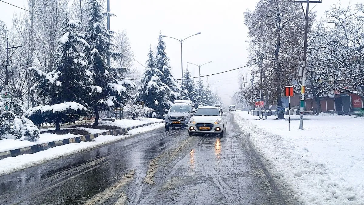
According to recent reports, the first snowfall of the 2025 season landed between October 5–7, primarily across elevated areas such as Gulmarg, Sonamarg, Pahalgam, and Zojila Pass. This is consistent with IMD warnings of an active Western Disturbance expected over that period. The Economic Times
This early snow has already had visible consequences:
-
Road blockages in mountainous routes and passes.
-
Temperature dips across the Valley, with minima in the realm of 5–8 ℃.
-
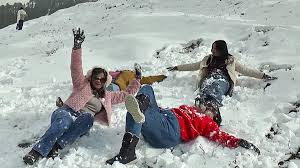
A surge in winter tourism bookings, especially in regions renowned for snow sports and scenic cover.
The IMD also issued alerts that light to moderate rainfall might hit lower-lying areas of J&K concurrently, due to the same weather system. The Economic Times
Ground Verifications & Local Observations
Independent local news and tourism sources confirm similar patterns:
-
Several roads, especially in the Gulmarg–Drung route and around Sonamarg, were temporarily closed owing to snowfall and slush accumulation.
-
Tour operators in Pahalgam and Betab valley report increased demand for snow-viewing packages earlier than usual.
-
Several valley residents have posted images of first snow on hills around Srinagar, confirming the chill creeping downward.
While early snow at high altitudes isn’t unprecedented, its timing and intensity are noteworthy and may indicate a more active winter regime than in milder years.
Caveats & Context
That said, a few caveats are essential:
-
Early snowfalls are more likely at the highest elevations; they do not always translate into heavier accumulation in mid-elevations.
-
One spell of snow is not proof of the overall seasonal trend—many winters see early flurries but then settle into normal patterns.
-
Microclimates matter: southern slopes, leeward areas, and wind-exposed ridges may see different impacts than sheltered valleys.
Nevertheless, the early snowfall is a strong early signal that the winter machinery has begun turning earlier than usual this season.
Rain-Laced Chill Spreads Across North India
The cold and damp are not restricted to the Kashmir Valley. A confluence of weather systems is bringing unseasonal precipitation and chill into north Indian plains.
Western Disturbances & Extended Rainfall
One of the primary drivers is Western Disturbances—meteorological systems originating in the Mediterranean region that travel eastward across northern India. These systems bring moisture, cloud cover, rain, and sometimes snow into the Himalayan belt and adjoining plains.
In recent weeks, persistent disturbances have carried rain, thunderstorms, and gusty winds into Haryana, Punjab, Uttar Pradesh, and Delhi. Delhi’s minimums have dropped to around 20 ℃ after days of rain, and flight diversions, traffic disruptions, and low visibility have been widely reported.
These disturbances help maintain a wet chill by preventing daytime heating (via clouds) and inducing nocturnal cooling.
Broader Patterns & Cold Waves
Media and official forecasts also warn that as the deeper winter sets in, cold wave and severe cold wave conditions may manifest in pockets of Himachal Pradesh, Punjab, Haryana, and J&K. Hindustan Times+2The Indian Express+2 For example:
-
From December 30 to January 2, IMD predicted cold wave to severe cold wave in Himachal and isolated areas of J&K, Punjab, Haryana, Rajasthan. Hindustan Times
-
Images and weather bulletins spotlight plummeting temperatures, frost, and snowfall in hills as plains endure chilly, damp conditions. The Indian Express
The coupling of Western Disturbances with possibly stronger cold advection (from polar or midlatitude influxes) could yield enhanced chill over northern India.
Contrast with “Warmer January” Forecasts
Interestingly, some Indian forecasts project that January 2025 may be warmer than usual across most of India, except certain regions in eastern and northwestern India. India TV News+1
This apparent contradiction underscores the high variability in winter forecasts. It is plausible that certain days or weeks may trend warmer, while others see deeper cold spells. Local or regional anomalies may override averaged trends.
Impacts Beyond Temperature
The consequences of more rainfall, snow, or chilling conditions in the plains and valleys are not limited to discomfort. They extend to:
-
Disruption in transport, flights, and road movement due to waterlogging, fog, and storms.
-
Health stresses, especially for vulnerable populations (elderly, children) due to sudden cold.
-
Impacts on energy demand (heating needs), urban flooding, and visibility for transport.
Thus, the broader “rain-laced chill” is an integral part of the narrative shaping North India’s winter story this year.
What to Expect in the Heart of Winter: December–January
While early signals give useful hints, the real test lies in December and January — the core of the Himalayan winter. What can J&K realistically expect?
Temperature Projections & Extremes
From expert commentary and analog years, a plausible lower bound for valley minima is around –8 ℃ during peak winter. (Summary)
However, extreme dips below that are not being strongly forecasted at present. That cautious restraint is sound: many winters have seen sub-zero and even –10 ℃ to –15 ℃ in sheltered spots, but averages often stay in the –5 to –10 ℃ range, depending on altitude, wind, and snow cover.
Notably:
-
In January 2025, reports confirm the Kashmir Valley endured intense cold, with temperatures dropping below freezing in numerous places and snow predicted in upper reaches. India TV News
-
Dense fog, snow, and cold wave conditions in plains during early January 2025 were captured in media reports and photographs. The Indian Express+2Hindustan Times+2
-
IMD and major outlets did issue forecasts of colder-than-average spells and occasional severe cold in J&K and adjacent hill states during the 2024–25 winter cycle. Patna Press+3Hindustan Times+3The Times of India+3
Thus, projecting valley lows of –8 ℃ is within reason, with possibility of harsher pockets.
Snow Accumulation Patterns
The depth, timing, and persistence of snow cover will be crucial. Some expectations:
-
Frequent moderate snow spells may alternate with dry periods, instead of a single continuous accumulation.
-
Higher elevation passes and glacier zones may see sustained snow cover, which in turn reflects radiation and reinforces cold near those zones.
-
Mid-elevation belts and valley slopes may have intermittent snow depending on storm strength and duration.
Given the early snowfall already, the snow season may begin earlier, giving longer windows for accumulation or melt cycles.
Duration & Extremes
If the winter is indeed more active:
-
The “snow season” could prolong by a few weeks on either end.
-
Cold waves may be more frequent or last longer.
-
Thaw-freeze cycles, frost reversals, and slushy conditions might appear, especially in the valley floor.
But caution: long-term consistency matters more than one or two cold snaps. Forecast uncertainty remains high for cumulative precipitation and extreme cold persistence.
What This Means for Travelers & Locals
A more active, chillier, snowier winter in J&K carries both opportunities and risks. Below is a practical guide for residents, visitors, and service providers.
For Travelers & Tourists
1. Travel Timing & Duration
-
Plan earlier: Snow-based tourism (skiing, snow treks) may start earlier than usual, so booking for November–December may now make sense.
-
Flexible itinerary: Mountain roads may close unexpectedly; buffer extra days or alternate routes.
2. Gear & Clothing
-
Layer up: Thermal innerwear, windproof jackets, gloves, wool caps, socks.
-
Footwear matters: Waterproof boots with grip are essential — not just for snow but slush and ice.
-
Emergency kit: Flashlights, portable chargers, first aid, emergency blankets, high-energy food.
3. Travel Safety & Alerts
-
Always follow official advisories — IMD, local meteorological centres, state traffic alerts.
-
Be alert to road closures, avalanches, landslides especially on approaches to high passes.
-
Carry contact numbers of local rescue services, road control, and check-in with lodging providers.
4. Booking & Accommodation
-
Homestays and hotels in key valleys (Gulmarg, Pahalgam, Sonamarg) are seeing spikes in early bookings.
-
Properties offering snow-viewing, guided treks, skiing packages may fill up fast.
-
Always confirm accessibility in bad weather before arrival.
For Locals & Authorities
1. Infrastructure Preparedness
-
Roads (especially mountain passes) need snow-clearing equipment, grit/rock salt, and early maintenance.
-
Local electricity, heating systems, and water supply (pipes, snowmelt channels) should be winterized.
-
Emergency centers and shelters should be readied in remote villages.
2. Tourism & Local Economy
-
Resorts, tour operators, and homestays should gear up staff, stock supplies, and promote early-winter packages.
-
Safety training for mountaineering guides, snow-sport operators, and local drivers is critical.
-
Communication campaigns for tourists (dos and don’ts in snow, acclimatization advice, rescue contacts) will help reduce accidents.
3. Community Health & Vulnerable Groups
-
Cold shelters for the elderly, distribution of warm clothing, and awareness about cold-related illnesses (hypothermia, frostbite) are essential.
-
Local administrations should coordinate health camps, especially in remote hamlets.
Risks, Uncertainties & Alternate Scenarios
While many signals point toward a perhaps gloomier winter, it is vital to understand what might push things differently. Below are key factors, alternate possibilities, and risk adjustments.
Forecast Uncertainty & Variability
-
Model divergence: Seasonal forecasts from different agencies can vary widely, especially with mountain microclimates.
-
Breaks and dry spells: Even active winters have intermittent warm or dry episodes; prolonged snow-free windows can alter energy balance.
-
Local deviations: Valleys, leeward slopes, and microclimates may not replicate patterns seen at higher elevations.
Potential Moderators
-
A weak or delayed La Niña may reduce its influence.
-
Westerlies positioning and strength of Western Disturbances may shift, altering precipitation patterns.
-
Warm air intrusions from lower latitudes or mid-latitude systems could temper cold spells.
Alternative Outcome: A Mild-to-Moderate Winter
While many forecasts suggest a more chilling season, a milder pattern is not off the table:
-
A neutral ENSO phase (neither El Niño nor La Niña) might emerge, bringing more ordinary winter behavior.
-
If snowpack fails to sustain, subsequent radiational cooling may moderate.
-
Thin cloud cover or prolonged sunny days can mitigate frost and deeper cold in valleys.
Thus, while preparing for a tougher winter is prudent, no dramatic extremity is guaranteed.
How 2025 Compares with Recent Winters
Putting 2025 in context helps calibrate expectations.
Historical Snow Patterns & Chill in J&K
-
Typically, snowfall in Kashmir begins by late October to mid-November. Tripadvisor
-
The local tradition of Chillai Kalan (the harshest 40-day cold period from December 21 to January 30) still guides expectations of when the worst of winter may settle. Tripadvisor
-
In winters influenced by La Niña or other cold surges, snow events in December and January tend to intensify, leading to higher accumulation and prolonged coverage.
2024–25 Winter Highlights
-
In early 2025, the Kashmir valley already endured deep cold and snow in January. India TV News
-
Cold wave warnings were issued across North India, including J&K, for isolated severe cold spells. Hindustan Times
-
Despite that, some forecasts noted warmer-than-normal minimum temperatures in many regions in January 2025 — an anomaly perhaps pointing to variability. India TV News+1
These patterns suggest that 2025’s winter is not without precedent in its fluctuations, but the early signals are leaning toward above-average activity.
Conclusions & Takeaways
As of early October, Jammu & Kashmir appears to be entering a winter that may be wetter, colder, and longer than recent seasons. Some of the key takeaways:
-
Early snowfall in October is a strong early indicator that the winter “machine” has fired up sooner.
-
Western Disturbances will continue shaping rain/snow patterns in J&K and adjacent plains, enhancing cloud cover and chill.
-
The possible return of La Niña by late 2025 may act as a reinforcing agent favoring more intense cold and snow episodes.
-
Temperatures may dip to around –8 ℃ in valley zones during peak months, with localized colder pockets.
-
Risks include transport disruption, power stress, avalanche danger, and strain on tourism infrastructure.
-
For travellers, the message is: plan early, stay flexible, gear up, and follow official advisories.
-
For authorities and locals, winter preparedness — from road equipment to emergency shelters and health services — is more critical than ever.
That said, we must maintain humility in forecasting. The Himalayan climate is notoriously capricious, and one or two strong storms don’t define the entire season. A mild or moderate winter still lies within the realm of possibility, especially if key drivers like Western Disturbance alignment or La Niña strength deviate from expectations.