Big Projects, Little Relief: Kashmir’s 7th Close Flood Call Since 2014
By: Javid Amin | 04 Sep 2025
A Valley on Edge — The Seventh Flood Scare
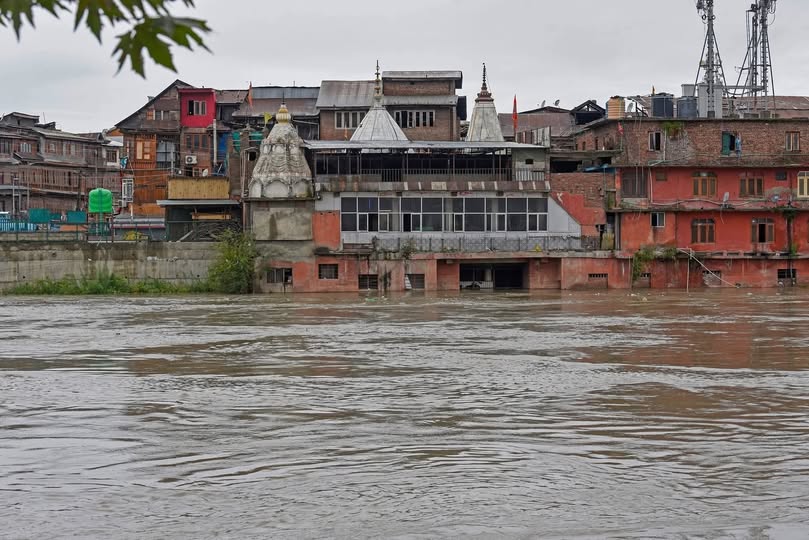
Srinagar, September 4, 2025 — As the Jhelum River surged past danger marks at Sangam and Ram Munshi Bagh this week, residents of Kashmir held their breath. Sirens blared, mosque loudspeakers echoed warnings, and families in low-lying areas scrambled to move valuables to higher floors. For many, the unfolding crisis felt like déjà vu — the haunting shadow of September 2014 returning once again.
This was not an isolated scare. It was the seventh close flood call since 2014, each one reminding Kashmiris of their fragile existence on the floodplains of the Jhelum. Despite over ₹1,500 crore invested through World Bank and government-backed schemes like the Jhelum and Tawi Flood Recovery Project (JTFRP) and the Comprehensive Flood Management Plan (CFMP), the Valley remains perilously exposed.
Less than 48 hours of rain were enough to push water levels near disaster thresholds. It raises an unsettling question: Why is Kashmir still waiting for real flood protection, 11 years after its worst disaster?
The Geography of Vulnerability
To understand Kashmir’s flood risk, one must first grasp its geography.
The Jhelum River is the Valley’s lifeline, flowing from Verinag in South Kashmir to Wular Lake in Bandipora before meandering into Pakistan. But its natural capacity is shockingly low compared to modern needs.
-
At Sangam (Anantnag) — the first major flood gauge station — the danger mark is set at 25 feet.
-
In Srinagar’s Ram Munshi Bagh, it is just 21 feet.
-
In contrast, the 2014 floods saw Sangam rise to 34.7 feet and Ram Munshi Bagh to 29.5 feet.
The Valley’s bowl-like topography means water has no quick outlet once the river overflows. Tributaries like Vishow, Rambiara, Lidder, and Doodh Ganga only add to the surge.
Compounding the problem is unregulated urban expansion. Wetlands, flood channels, and riverbanks — nature’s shock absorbers — have been steadily eaten up by roads, colonies, and shopping complexes.
When rains come hard, Kashmir simply has nowhere for the water to go.
2014 Floods: The Memory That Still Haunts
Ask any Kashmiri about September 2014, and their voice lowers. The trauma is etched in collective memory.
That month, South Kashmir received record rainfall — more than 250 mm in just four days. The Jhelum swelled beyond recognition, embankments crumbled, and within hours, Srinagar city was submerged.
-
200+ people lost their lives.
-
Nearly 10 lakh residents were displaced.
-
Property damage ran into tens of thousands of crores.
-
Businesses, hospitals, schools, and heritage sites drowned.
Dal Gate, Rajbagh, Bemina, Jawahar Nagar — Srinagar’s key neighbourhoods turned into islands. Rescue boats, mostly borrowed from locals, became the only means of transport.
Eleven years on, the Valley has seen seven more close calls — 2015, 2017, 2018, 2020, 2022, 2024, and now 2025. Each time, the same fear grips residents: “Will it be another 2014?”
Promises vs. Reality: The Projects That Failed to Deliver
JTFRP — Jhelum and Tawi Flood Recovery Project
Launched in 2015 with $250 million (₹1,600 crore) World Bank funding, JTFRP was marketed as Kashmir’s shield against another catastrophe. Its focus was twofold:
-
Strengthen infrastructure (embankments, bridges, public buildings).
-
Enhance resilience (disaster preparedness, community awareness).
But ten years later, much of JTFRP’s impact remains invisible on the ground. Bridges were repaired, some hospitals upgraded, but the core mission — restoring the Jhelum’s carrying capacity — remains incomplete.
The deadline has now been extended to August 2026, but residents ask: Will we survive another flood before it finishes?
CFMP — Comprehensive Flood Management Plan
Parallelly, the Centre rolled out the CFMP in phases, aiming to:
-
Dredge the Jhelum to deepen its channel.
-
Expand flood spill channels built in the 1900s by Dogra rulers.
-
Strengthen embankments across South and Central Kashmir.
Yet progress is painfully slow.
No major dredging has been carried out in the last five years. The outflow channel at Bemina remains clogged. Floodplains in Hokersar, Bemina, and Narbal have been lost to encroachments.
Experts now warn: “Kashmir is as vulnerable today as it was in 2014 — perhaps even more, because population density has grown.”
De-Siltation Delays: The Missing Link
Every river needs dredging. Silt builds up over years, reducing depth and water flow. For the Jhelum, dredging is not optional — it is survival.
In 2015, officials promised to increase the Jhelum’s carrying capacity from 35,000 cusecs to 60,000 cusecs. Ten years on, it barely holds 40,000.
Private contractors brought in dredgers, but disputes over payments, alleged corruption, and lack of political will left projects abandoned. Locals in Sangam and Pampore point to half-finished dredging pits as proof of negligence.
The result? Each spell of heavy rain brings water perilously close to danger marks.
Wetlands Lost: Kashmir’s Natural Flood Insurance Destroyed
Kashmir once had an ecosystem designed to absorb excess water. Wetlands like Hokersar, Narkara, Bemina, Haigam, and Shallbugh acted as natural buffers.
But today, these wetlands are shadows of their past:
-
Hokersar, once 13.5 sq km, has shrunk by over 50% due to encroachments.
-
Bemina flood basin is now a concrete jungle of colonies and institutions.
-
Narkara has been sliced into housing plots.
By destroying wetlands, Kashmir has dismantled its own safety net. What nature offered for free, policy has failed to preserve.
Encroachments & Urban Chaos
The Srinagar Development Authority (SDA) and successive governments have looked away as residential colonies mushroomed on floodplains.
-
The Flood Spill Channel, built in 1903 to divert excess water from the Jhelum, is now choked by encroachments.
-
Roads and malls line the banks, narrowing natural drainage.
-
Even government offices and police housing have been built on what were once water retention basins.
When floods come, water simply reclaims what was stolen from it — submerging homes, schools, and roads built on its path.
Climate Change: The New Flood Multiplier
Global warming is no longer abstract in Kashmir. It is here, reshaping weather patterns.
-
The Valley is witnessing more intense, short-burst rainfall events.
-
Snow in the mountains melts earlier, swelling rivers sooner.
-
Monsoonal shifts are bringing heavier downpours to the Himalayas.
Meteorologists warn that extreme weather events are now 3x more likely in Kashmir than they were two decades ago.
This means that even if projects like JTFRP and CFMP succeed, without climate adaptation, the Valley will continue facing existential flood threats.
Community Stories: Lives on the Edge
Mohammad Altaf, Baramulla farmer:
“Every September we pray more than we harvest. Apples rot if trucks don’t move, and floods drown our orchards. What’s the use of promises when one night of rain can destroy a year of labour?”
Shazia, Rajbagh resident:
“In 2014, we lost our home. Eleven years later, nothing has changed. The fear comes back with every rainfall — the children still ask if the water will enter again.”
Arif, Shopian trader:
“We hear about crores of rupees sanctioned for flood projects. But on the ground, we still see broken embankments and silted canals. Where does the money go?”
These are not isolated voices — they represent a Valley trapped between nature’s fury and governance failure.
How Others Beat Back Floods: Lessons for Kashmir
-
Netherlands: Built a world-class “Room for the River” program, expanding floodplains instead of narrowing them.
-
Bangladesh: Uses community-driven embankments and early-warning systems to save thousands of lives annually.
-
Kerala (2018 floods): After disaster, the state invested in data-driven flood forecasting and watershed management.
Kashmir can learn: flood resilience is not about concrete projects alone, but about living with rivers, not against them.
Policy Paralysis & Corruption: Why Projects Fail
Interviews with former engineers and bureaucrats reveal a grim truth:
-
Funds meant for dredging diverted to “beautification”.
-
Projects stuck in tender disputes for years.
-
Political instability delaying approvals.
The Audit and CAG reports repeatedly flagged these gaps. But without accountability, the cycle continues: flood → promises → funds → little change → another flood.
The Way Forward: A Roadmap for True Resilience
Experts suggest a five-pronged plan:
-
Complete dredging of Jhelum and Flood Spill Channel within 2 years.
-
Restore wetlands with strict eviction of encroachments.
-
Implement modern forecasting using AI and satellite models.
-
Community-driven preparedness — train locals in rescue, build storage for essentials.
-
Climate adaptation policy that integrates urban planning with water management.
Only then can Kashmir hope to break free of its cycle of fear.
FAQs
Q: Why is Kashmir so vulnerable to floods?
Because of its bowl-shaped geography, silted rivers, vanishing wetlands, and unregulated urbanization.
Q: What was the worst flood in Kashmir’s history?
The September 2014 flood, when the Jhelum rose to record levels, killing over 200 and displacing 10 lakh.
Q: What are JTFRP and CFMP?
World Bank and government-backed flood management projects aimed at dredging, embankment strengthening, and disaster preparedness in J&K.
Q: Has dredging been completed in Jhelum?
No. Despite promises to expand carrying capacity, dredging has largely stalled over the past 5 years.
Q: What can be done to prevent floods in Kashmir?
Restoring wetlands, completing dredging, strict land-use laws, climate adaptation, and community preparedness.
Editorial Closing
Kashmir today stands at a crossroads. Eleven years, thousands of crores, and countless promises later, the Valley still trembles when clouds gather. Each close call since 2014 is a warning that the next disaster may not spare us.
Floods are no longer just natural disasters here — they are policy failures, magnified by climate change.
If the government does not act decisively now, history may soon repeat itself with an even greater vengeance.