When the Lifeline of Kashmir Breaks
By: Javid Amin | 28 Aug 2025
The Jammu–Srinagar National Highway (NH-44) is not just a road—it is the economic, social, and emotional lifeline of Jammu and Kashmir. Stretching over 270 km, this arterial route connects the Kashmir Valley with the rest of India. Every truck carrying essential commodities, every tourist vehicle heading to Gulmarg or Pahalgam, every pilgrim traveling to Vaishno Devi or Amarnath—relies on this highway.
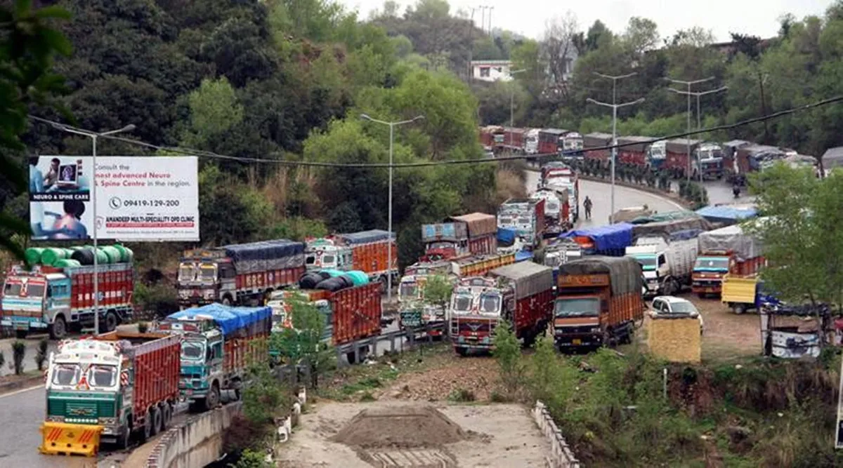
But in August 2025, relentless rainfall triggered multiple landslides in the Udhampur–Ramban belt, forcing authorities to shut the road for the third consecutive day. Over 500 vehicles remain stranded, locals are cut off from supplies, and the disruption is a stark reminder of the fragility of Himalayan connectivity.
This article dives deep into:
-
The latest updates on the highway closure
-
Impact on travelers, trade, and tourism
-
Government response and BRO’s herculean task
-
Socioeconomic challenges of recurring closures
-
Long-term solutions to secure Kashmir’s road connectivity
The Trigger: Torrential Rains & Himalayan Vulnerability
How Rain Turns Roads into Death Traps
The Himalayas are young, fragile mountains. Heavy monsoon showers, especially in August, saturate slopes, weakening rocks and soil. The result: landslides, mudflows, and slope collapses.
-
Jakheni to Chenani stretch witnessed multiple landslides, burying long patches of NH-44 under rocks.
-
Debris piled up near Mehar, Cafeteria Morh, Panthiyal, and Ramban, known “choke points” of the highway.
-
Torrential rainfall not only caused landslides but also triggered flash floods in nallahs (streams), washing away retaining walls and damaging culverts.
Climate Change Factor
According to IMD, rainfall intensity in J&K has risen by 18% over the last two decades. More “cloudburst-like events” and erratic monsoons amplify landslide risks.
Expert insight: Geologists warn that NH-44 sits on a seismically active and geologically unstable zone, making it highly prone to closures every year.
Key Updates from Ground Zero
-
Vehicular Ban: No traffic allowed from Nagrota (Jammu) toward Reasi, Chenani, Patnitop, Doda, Ramban, Banihal, or Srinagar.
-
BRO & NHAI Teams: Around 500 engineers and workers deployed with heavy machinery for debris clearance.
-
Alternate Roads Blocked: Mughal Road (Poonch–Shopian) and Kishtwar–Sinthan–Anantnag highway also remain shut due to rain-induced hazards.
-
Stranded Vehicles: Over 500 trucks and passenger buses stuck between Ramban and Banihal.
-
Weather Alerts: IMD has issued Orange and Yellow Alerts for Jammu, Ramban, Udhampur, Poonch, Rajouri, Anantnag, and Baramulla till September 1, 2025.
-
Essential Supplies: Petrol pumps in Srinagar and Anantnag report shortages, while vegetable and fruit prices have already shot up by 20–30%.
Advisory for Travelers
Authorities have urged travelers and pilgrims to exercise caution:
-
✅ Carry valid photo ID (especially from Udhampur or Katra) for passage through restricted zones.
-
✅ Confirm road status with Traffic Control Units (TCU Jammu: 0191-2459048 / 0191-2740550) before planning travel.
-
✅ Avoid venturing near rivers, landslide-prone slopes, or freshly cleared debris.
-
✅ For tourists: Prefer air travel to Srinagar until road conditions stabilize.
-
✅ Pilgrims for Vaishno Devi or Amarnath Yatra should monitor official advisories closely.
Socioeconomic Impact: Beyond Roadblocks
01. Supply Chain Breakdown
-
Kashmir relies on NH-44 for 90% of its essential supplies—fuel, food, medicines.
-
Truckloads of apples, Kashmir’s biggest horticulture export, risk rotting in stranded vehicles.
02. Tourism Shock
-
August–September is peak season for pilgrims and travelers.
-
With NH-44 and Mughal Road both closed, tourist inflow has dropped by 60% in the last week.
03. Economic Losses
-
Preliminary estimates suggest ₹250–300 crore worth of trade loss in just three days of closure.
-
Transporters, hoteliers, and small traders are the hardest hit.
04. Psychological Strain on Commuters
-
Stranded travelers, including families and children, face scarcity of food, water, and shelter.
-
Social media is flooded with images of people stuck in buses overnight, sparking anger against authorities.
Government & BRO Response
The Border Roads Organisation (BRO) and National Highways Authority of India (NHAI) are spearheading clearance:
-
Heavy earthmovers, JCBs, and drilling equipment are deployed round-the-clock.
-
Army and paramilitary units are assisting in relief for stranded commuters.
-
District administrations of Ramban and Udhampur have set up community kitchens at safe zones.
-
The government is exploring temporary aerial supply drops for medicines and baby food if the blockade prolongs.
Bigger Picture: Why NH-44 Closures Are a Recurring Nightmare
Recurrence of Closures
-
In 2022, NH-44 was closed for over 300 hours in monsoon season.
-
In 2023, a massive landslide at Ramban forced a 5-day closure, costing the economy ₹700 crore.
-
In 2025, the closure is yet another reminder that Kashmir’s connectivity crisis is not temporary—it is structural.
Alternate Roads Are Not Reliable
-
Mughal Road (historic Poonch–Shopian route): closed 5–6 months every year due to snow.
-
Kishtwar–Sinthan–Anantnag highway: narrow, underdeveloped, and risky in rains.
Air Travel Cannot Replace Road Access
While flights to Srinagar continue, air tickets are 10x costlier during such blockades, unaffordable for ordinary Kashmiris.
Long-Term Solutions: The Way Forward
-
All-Weather Tunnels
-
Completion of the Z-Morh and Zojila tunnels (connecting Sonmarg–Drass) must be expedited.
-
A Chenani–Nashri twin tunnel expansion can bypass fragile slopes.
-
-
Smart Engineering Interventions
-
Use of geo-textiles, slope stabilization nets, and retaining walls in Ramban sector.
-
Drone surveillance to monitor slope movement.
-
-
Diversification of Routes
-
Upgrading Mughal Road into an all-weather national highway.
-
Expediting Rail connectivity to Kashmir—the Udhampur–Srinagar–Baramulla railway line is 90% complete, but needs urgent push.
-
-
Climate-Resilient Planning
-
Incorporating climate change projections into highway construction.
-
Creating disaster-ready shelters and depots along NH-44.
-
Voices from the Ground
-
Truck driver Mushtaq Ahmad: “I’ve been stranded for 2 days near Ramban. My truck is full of apples. If I don’t deliver, I lose everything.”
-
Tourist from Delhi: “We came for Pahalgam but are stuck near Udhampur. Hotels are full, prices are high, and no clarity from authorities.”
-
BRO engineer: “Our men are working round-the-clock, but recurring slides keep undoing progress.”
Data Snapshot: Jammu–Srinagar NH-44 Closures (2015–2025)
| Year | Total Days Closed | Economic Loss (₹ Crore) | Major Cause |
|---|---|---|---|
| 2015 | 12 days | 400+ | Landslides, Snow |
| 2017 | 15 days | 500+ | Flash Floods |
| 2019 | 22 days | 850+ | Ramban Landslide |
| 2021 | 18 days | 600+ | Slope Collapse |
| 2023 | 9 days | 700+ | Major Ramban Slide |
| 2025 | 7+ days* | 800+ (est.) | Udhampur–Ramban Landslides |
(*as of August 2025)
Bottom-Line: Kashmir’s Connectivity at Crossroads
The Jammu–Srinagar National Highway closure in August 2025 is more than a traffic inconvenience—it is a socioeconomic emergency. Every closure disrupts trade, tourism, daily life, and shakes the fragile stability of Jammu & Kashmir.
Unless India invests in climate-resilient infrastructure, alternate routes, and railways, Kashmir’s connectivity will remain hostage to weather and landslides.
The people of Kashmir deserve not just a road, but a dependable lifeline—one that can withstand the tests of rain, rock, and time.


