Jammu and Kashmir ends Chillai Kalan with just 25% normal rainfall, experiencing erratic weather patterns, with mild rains and snowfall forecasted.
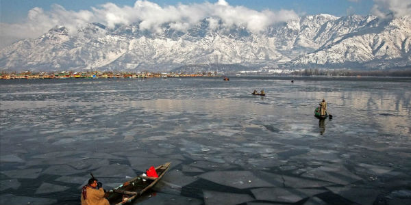
Some parts of Jammu and Kashmir witnessed mild rains in plains and snowfall over mountains on Friday as the Valley’s harshest winter period – Chillai Kalan – ended, recording just 25% of the normal precipitation, the meteorological centre said.
The 40-day Chillai Kalan, which started on December 21, has behaved erratically this winter starting with a bone chilling night temperatures of -8° to -12° Celsius but ending with day temperatures of 14-15° Celsius, some 6-7° above normal. The summer capital Srinagar witnessed cold wave for several days in the first half of Chillai Kalan which froze waterbodies, especially Dal Lake.
There have been three mild bouts of snowfall during the period, including on December 27-28, January 4-5 and January 16. But overall the winter has witnessed a deficit precipitation. Officials of the meteorological centre in Srinagar said that Chillai Kalan has recorded over 3/4th of deficit in precipitation.
“We had just a few days of precipitation this winter so far. Overall, there has been a deficit of 75% in Kashmir as well as in Jammu divisions,” said MeT’s Srinagar centre director Mukhtar Ahmad.
Senior meteorologist at MeT Srinagar, Mohammad Hussain Mir, said the weather has behaved erratically. “The weather has behaved abnormally this winter so far with nights more chilling than normal while days were warmer than normal. In terms of numbers, the minimum temperatures were 3-5 degrees below normal while days were 5-7 degrees above normal,” he said.
The weather experts had expected that the winter would be harsher with some good spells of precipitation owing to the La Nina global weather effect (La Nina effect is when winds from Pacific travel from East to West and is related to surface temperatures of sea water). However, that exactly has not happened this winter.
“The precipitation in Jammu and Kashmir is mainly due to Western Disturbance (WD) which is related to upper air winds and temperatures. La Nina and WD are not one-to-one related but can have coincidental effect on each other,” Mir said.
The MeT centre said rain and snowfall are likely from Friday night which may extend to Saturday.
The harsh winter period is followed by 20 more winter days (called Chillai Khurd) which are less intense and then lastly 10 days of mild cold (Chille Bache).