Lawaypora–HMT Highway Accidents: Facts, Causes, and Safety Fixes After Rising Crashes
By: Javid Amin | 16 December 2025
A Corridor Under Scrutiny
The Lawaypora–HMT highway stretch in Srinagar has quietly become one of the city’s most troubling traffic corridors.
Over the past year, a series of serious crashes—some fatal—have raised alarms among residents, commuters, and road safety observers. What was once seen as an ordinary urban highway is now being openly discussed in local media as a potential accident cluster zone, with repeated incidents sharing disturbing similarities.
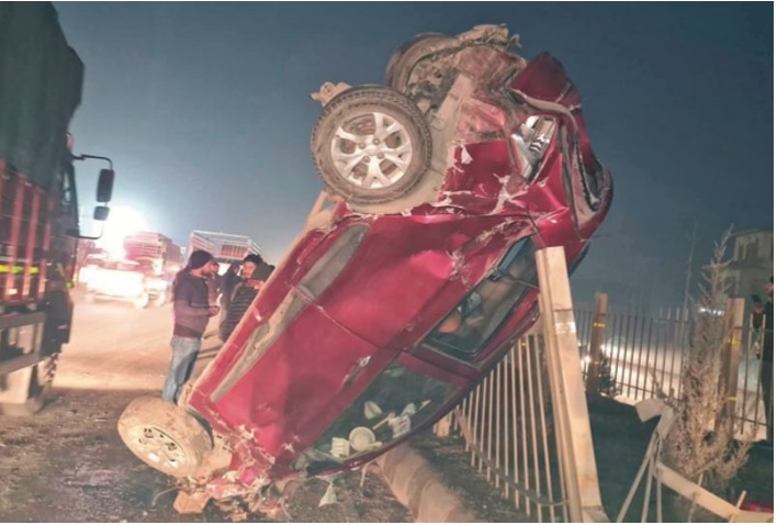
The turning point came with the widely reported SUV rollover near the Kirmani Sahib Shrine, where a teenager lost his life and others were critically injured after the vehicle reportedly flipped multiple times at high speed. Eyewitness descriptions of violent rollovers, combined with the frequency of incidents, forced a larger question into public view:
Why are so many serious accidents happening on this single stretch?
The Fatal Rollover That Focused Public Attention
The crash near Kirmani Sahib Shrine was not the first on the corridor—but it was among the most shocking.
According to eyewitness accounts reported by local media, the SUV was travelling at high speed before losing control and overturning multiple times. The severity of the crash, the age of the victims, and the location—close to a religious site and residential access points—sparked widespread concern.
Residents noted that:
-
Vehicles routinely travel fast through the area
-
Sudden turning movements are common
-
Pedestrian activity is frequent
-
There is little visible speed moderation near junctions
This incident transformed anecdotal concern into a public safety debate.
Not an Isolated Event: A Pattern Emerges
Local reporting over recent months has begun asking whether these crashes are connected by design and behavior, rather than coincidence.
Several common threads recur across incidents:
-
High-speed loss of control
-
Multiple rollovers, especially involving SUVs
-
Evening or low-visibility conditions
-
Young drivers
-
Crashes near access points rather than mid-block sections
When crashes cluster around similar locations and mechanisms, road safety experts worldwide treat them as systemic failures, not isolated driver errors.
Understanding the Crash Dynamics
1. Speeding and Rollover Risk
Speed consistently emerges as the single most critical factor in severe crashes on the Lawaypora–HMT stretch.
High-speed travel:
-
Reduces reaction time
-
Amplifies steering errors
-
Increases rollover probability for SUVs, which have higher centers of gravity
-
Turns minor misjudgments into catastrophic outcomes
Multiple rollovers, as described by eyewitnesses, are strong indicators of excessive speed combined with abrupt steering inputs.
2. Risky Maneuvers at Access Points
The fatal crash near Kirmani Sahib Shrine occurred not on an empty straight, but near an access zone where:
-
Local traffic merges onto the highway
-
U-turns and sudden lane changes occur
-
Speed differences between vehicles are significant
Such locations are known globally as conflict points, where:
-
Through-traffic expects uninterrupted flow
-
Local drivers make short, slow, or angled movements
-
Even small errors can trigger loss of control
Without channelization or controlled geometry, these points become rollover traps at speed.
3. Mixed Traffic in a High-Speed Environment
The Lawaypora–HMT corridor serves:
-
Residential neighborhoods such as Umerabad
-
Religious institutions
-
Daily local commuting needs
This creates mixed traffic conditions, where:
-
Pedestrians cross informally
-
Two-wheelers and slow vehicles enter suddenly
-
Through-traffic maintains highway-level speeds
High-speed design combined with local access is one of the most dangerous configurations in urban road safety.
4. Visibility and Time-of-Day Risks
Several reported crashes occurred during evening hours, when:
-
Light levels drop rapidly
-
Headlight glare increases
-
Contrast between road users reduces
-
Fatigue may set in
At high speeds, reduced visibility dramatically increases the likelihood of:
-
Late braking
-
Overcorrection
-
Sudden swerves leading to rollovers
5. Young Driver Vulnerability
Teen involvement in at least one fatal crash highlights a well-documented global risk factor.
Young drivers are statistically more likely to:
-
Underestimate speed
-
Overestimate control
-
Engage in thrill-seeking behavior
-
React aggressively to unexpected situations
When youth, speed, and SUVs intersect on a mixed-use corridor, crash severity escalates sharply.
Identified High-Risk Zones on the Corridor
Kirmani Sahib Shrine Junction
This area combines:
-
Religious footfall
-
Informal pedestrian crossings
-
Turning traffic
-
Speeding through-traffic
Without speed moderation or channelized movements, it functions as a high-risk node.
Umerabad–HMT Approaches
The fact that victims were identified as residents of Umerabad suggests:
-
Frequent local entry and exit
-
Daily familiarity breeding complacency
-
Repeated exposure to the same conflict points
Regular users often underestimate risk on familiar roads, increasing crash likelihood.
What’s Missing—and Why It Matters
No Public Engineering Audit
Despite repeated incidents, there is no publicly available road safety audit detailing:
-
Lane widths
-
Median opening design
-
Shoulder conditions
-
Superelevation
-
Sight distances
Without this data, fixes remain reactive rather than systemic.
Limited Speed and Enforcement Transparency
Media reports emphasize speed, yet:
-
Average vehicle speeds are not published
-
Camera coverage is unclear
-
Targeted enforcement data is absent
Speed management without data is policy in the dark.
No Visible Conflict Mapping
Pedestrian crossings, bus stops, and informal U-turns are rarely mapped publicly, even though they often explain crash clusters more accurately than driver behavior alone.
Immediate, High-Impact Safety Fixes
1. Speed Management
-
Introduce average-speed cameras along the corridor
-
Set speeds appropriate for mixed access
-
Use gateway treatments—rumble strips, visual narrowing, advance warning signs—before junctions
2. Access Control and Road Geometry
-
Close unsafe median openings
-
Formalize necessary ones with protected turn pockets
-
Add acceleration and deceleration lanes
-
Channelize pedestrian movement using guardrails and refuges
3. Visibility Improvements
-
Upgrade lighting near access points
-
Improve retroreflective markings
-
Install blackspot hazard boards naming the risk explicitly
4. Behavioral and Enforcement Measures
-
Target enforcement during evenings and weekends
-
Publicize penalties for speeding and stunt driving
-
Conduct youth-focused safety programs in nearby schools and communities
Data-Backed Next Steps for Authorities and Media
Rapid Road Safety Assessment
A 30-day audit should examine:
-
Speed patterns
-
Crash locations
-
Lighting and signage
-
Geometry flaws
Findings should be publicly released with timelines.
Crash Data Transparency
Disaggregated police crash data—time, vehicle type, maneuver—would:
-
Validate media-reported patterns
-
Build public trust
-
Enable evidence-based fixes
Before–After Evaluation
Implement fixes at two priority junctions, track results for six months, and adjust interventions based on outcomes.
Beyond Headlines: A Preventable Tragedy Corridor
The Lawaypora–HMT highway accidents are not random.
They reflect a predictable interaction between speed, design, and human behavior on a corridor that has outgrown its original function.
Every rollover tells the same story:
-
Speed without moderation
-
Access without control
-
Risk without warning
Until these elements are addressed together, the corridor will remain dangerous—regardless of who is behind the wheel.
The data already points to solutions. What is needed now is action.