Kashmir Weather Update: Gusty Winds, Heavy Rain, and MeT Warnings | IMD Forecast
By: Javid Amin | 31 Aug 2025
Kashmir witnessed a dramatic turn in weather on Sunday evening, as a powerful system brought moderate to heavy rainfall, thunderstorms, and strong gusty winds across several districts. The stormy conditions, which disrupted normal life, come amid a broader monsoon surge across North India.
Affected Areas: Srinagar, Budgam, South Kashmir
-
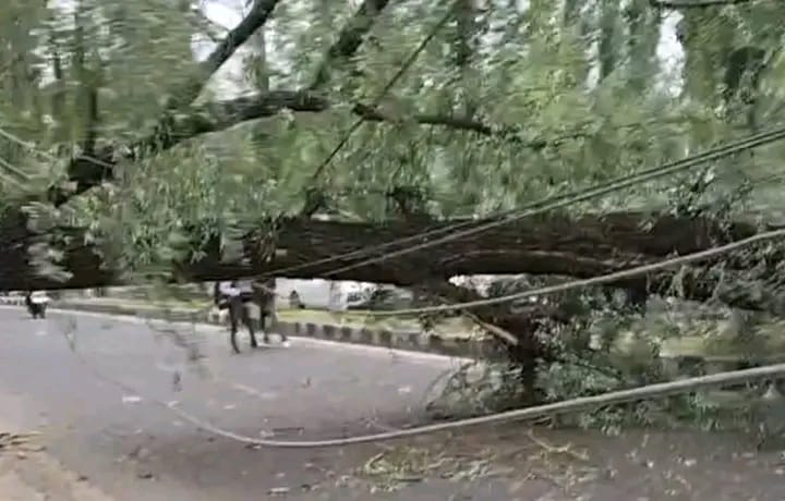
Srinagar city saw streets waterlogged as heavy rain combined with strong winds, uprooting trees and damaging electric lines in some neighborhoods.
-
Budgam and Pulwama reported hail in certain pockets, adding to agricultural losses already caused by earlier downpours.
-
South Kashmir districts including Anantnag and Kulgam faced heavy showers, leading to swollen streams and flash flood threats.
As a precautionary measure, Dal Lake, Wular Lake, and other water bodies were closed for boating and shikara rides. Authorities have warned tourists and locals against venturing into water during the stormy spell.
Weather Warnings & Extended Forecast
According to the Meteorological Department (MeT), the region remains vulnerable to weather-related hazards in the coming days:
-
🌊 Flash Flood Risk: Continuous rainfall has raised water levels in streams and tributaries, heightening the danger of flash floods.
-
🏔️ Landslides & Mudslides: Vulnerable mountain slopes, particularly along Srinagar–Jammu National Highway, remain at risk.
-
🌧️ Very Heavy Rainfall in Jammu: On September 2, districts of Jammu division are expected to receive very heavy to extremely heavy rainfall, with possible road blockages.
-
🌦️ Extended Showers: The Valley will continue to witness light to moderate rain and thunderstorms until September 8, with occasional heavy spells.
District-Level Advisories
Several districts, including Pulwama, Anantnag, and Kupwara, have activated emergency protocols in response to the warnings:
-
🚫 Residents in low-lying areas and near rivers/nallahs have been asked to stay indoors.
-
🛶 Ferry and boating operations have been suspended in flood-prone zones.
-
📞 Emergency helplines and control rooms have been set up to assist people in case of waterlogging, power disruptions, or flood-related incidents.
Broader Monsoon Impact Across North India
This localised storm in Kashmir is part of a larger weather pattern affecting the Himalayan belt. The India Meteorological Department (IMD) has highlighted:
-
🌧️ Above-Normal Rainfall in September — North India, especially hilly states, will receive excess rainfall.
-
🌪️ Delayed Monsoon Withdrawal — The monsoon is not expected to retreat in the first week of September, as a fresh low-pressure system is forming over the Bay of Bengal.
-
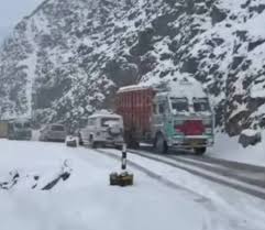
❄️ High-Altitude Anomalies — Unseasonal snowfalls, such as the recent Ladakh event, may recur due to interaction between monsoon currents and western disturbances.
Why This Matters: Climate & Safety
The sequence of gusty winds, cloudbursts, floods, and snowfalls underscores Kashmir’s growing vulnerability to climate variability. Experts warn that:
-
Rapid urbanisation, deforestation, and encroachment of floodplains amplify the impact of such storms.
-
Preparedness, early-warning systems, and citizen cooperation will be key in minimising disaster impacts this monsoon season.