Kashmir on the Brink of Collapse: Disaster at Our Doorstep
By: Javid Amin | 04 Sep 2025
A 2025 ground analysis of the Valley’s flood threat, readiness gaps, and the urgent choices before us.
The Water is Rising — Again
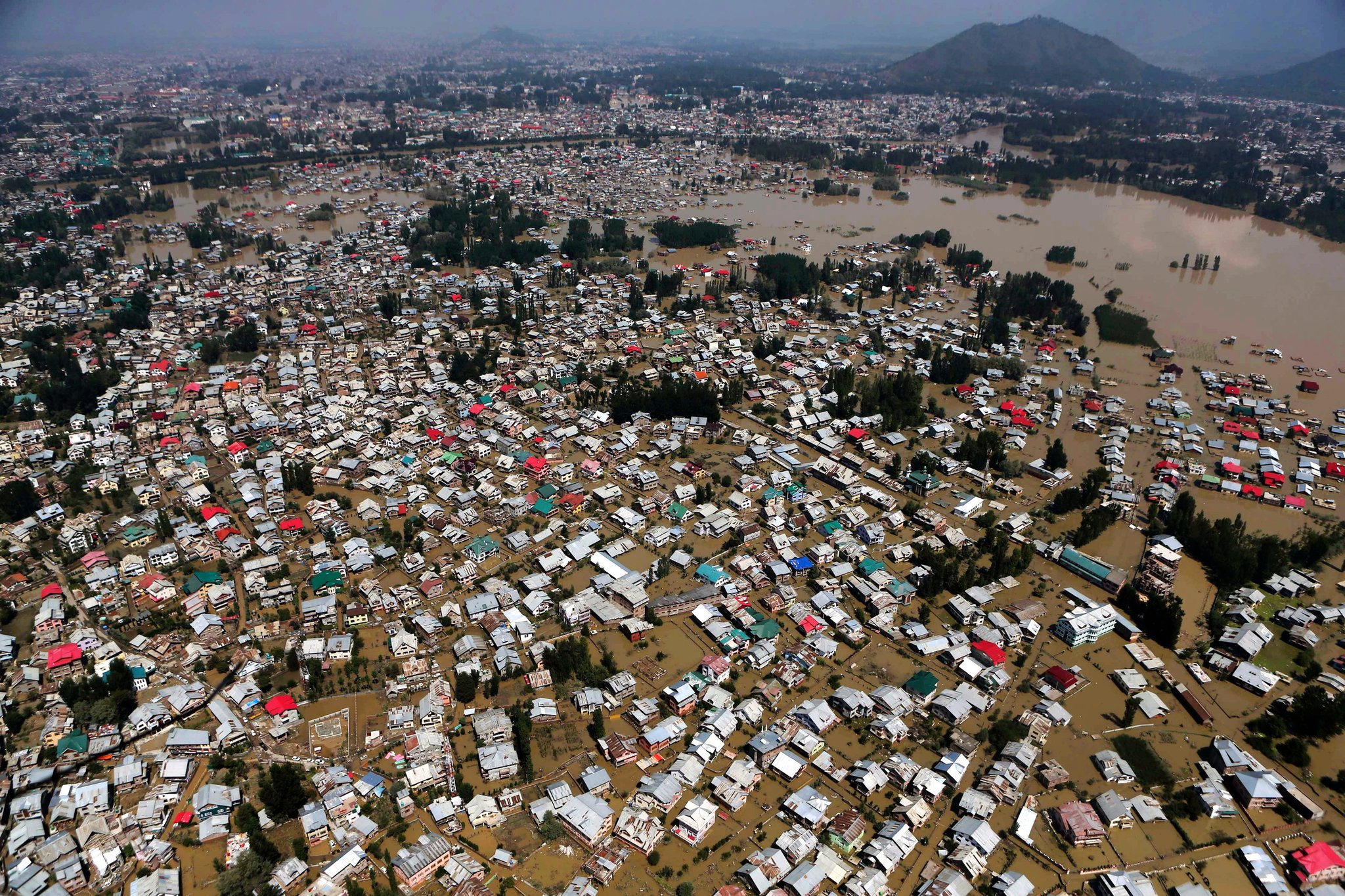
The Valley is holding its breath. The Jhelum has crossed the danger mark at Sangam and is swelling past safe limits in Srinagar. Tributaries like Vishow and Rambiyara are spilling over, and the rain hasn’t stopped. In South Kashmir, fields are lakes; in Srinagar’s low-lying colonies, water is already at doorsteps.
This is not a drill. It’s the same creeping dread we felt in September 2014 — only this time, we had eleven years to prepare.
Current Flood Status — September 2025
01 Rivers & Rainfall
- Jhelum River: Above danger mark at Sangam (27.15 ft) and Ram Munshi Bagh (20.54 ft).
- Tributaries: Vishow Nallah (10.75 m) and Rambiyara Nallah (5.40 m) overflowing.
- Rainfall: Reasi (230 mm), Katra (193 mm), Batote (157 mm) — extreme precipitation saturating catchments.
- Urban Flooding: Bemina, Chanapora, Kursoo, Padshahi Bagh, Peerbagh already inundated.
02 Flash Flood Alerts
- South Kashmir: Kulgam, Pulwama, Anantnag — high risk from tributary overflow.
- Jammu Division: Chenab and Tawi rivers in full spate; low-lying Jammu city areas under water.
Preparedness — How Ready Are We?
01 What’s in Place
- High alert declared; gauges monitored 24/7.
- Preventive evacuations in high-risk pockets.
- 300+ relief shelters stocked with food, blankets, water.
- NDRF, SDRF, Army on standby with boats and rescue gear.
- Schools closed to keep children safe.
02 What’s Missing
- De-siltation backlog: The Jhelum’s carrying capacity remains dangerously low.
- Encroached floodplains: Construction continues where water should flow.
- Drainage bottlenecks: Urban drains can’t cope with even moderate rain.
- Long-term resilience: Still more talk than action.
The Most Volatile Areas Right Now
Srinagar
- Rajbagh, Jawahar Nagar, Gogji Bagh — historically worst-hit.
- Bemina, Chanapora, Kursoo, Padshahi Bagh, Peerbagh — already waterlogged.
- Lal Chowk — on the official high-risk list.
South Kashmir
- Sangam (Anantnag) — Jhelum above danger mark.
- Kulgam & Pulwama — tributaries overflowing.
- Pampore — high alert.
Jammu Division
- Low-lying Jammu city localities — Nanak Nagar, Gandhi Nagar, Shastri Nagar, Narwal, Bhatindi.
- Chenab basin — Doda, Bhaderwah, Reasi, Ramban.
Safer Havens
While no area is entirely risk-free during extreme rainfall, relatively safer zones include:
- Higher ground away from riverbanks and flood channels.
- North Kashmir districts like Kupwara and Bandipora (except Wular fringes).
- Elevated Srinagar localities — Hyderpora heights, parts of Zakoora, Harwan.
- Designated relief shelters — over 300 across districts.
- Army and government complexes on raised plinths.
Eleven Years After 2014 — Why Are We Still Here?
The 2014 floods were supposed to be a turning point. We were promised:
- Comprehensive dredging of the Jhelum.
- Restoration of wetlands and flood channels.
- An alternate flood channel.
- Strengthened embankments.
- Modern flood forecasting systems.
What we got:
- Sporadic dredging, often abandoned midway.
- Wetland restoration projects without enforcement.
- Alternate flood channel still on paper.
- Embankment repairs in patches.
- Forecasting systems improved, but not matched by structural resilience.
The Structural Weaknesses We Can’t Ignore
01 De-siltation Deficit
Silt has raised the Jhelum’s bed, reducing its capacity. Without continuous dredging, every heavy rain is a gamble.
02 Wetland Loss
Hokersar, Anchar, Wular — once natural sponges — are shrinking under encroachment and pollution.
03 Floodplain Encroachment
Bridges, flyovers, ring roads, and colonies have eaten into nature’s overflow zones.
04 Climate Change
Erratic rainfall, cloudbursts, and warmer winters are altering the Valley’s hydrology.
What Must Change — Now
- Permanent de-siltation programme — not one-off dredging.
- Wetland restoration — revive Hokersar, Anchar, Wular as flood buffers.
- Strict floodplain zoning — no more colonies, malls, or roads in overflow zones.
- Urban drainage overhaul — Srinagar’s stormwater system needs a complete redesign.
- Community-led preparedness — local volunteers trained and equipped for first response.
The Bottom Line
Kashmir is in a high-alert flood scenario. The immediate response machinery is active — shelters, rescue teams, advisories — but structural vulnerabilities from years of underinvestment mean the Valley remains dangerously exposed.
If rainfall continues at current intensity, low-lying Srinagar, South Kashmir river belts, and parts of Jammu city could see severe inundation within hours. The safest course for residents in flagged zones is to move to designated shelters or higher ground immediately.
“The water is rising. The question is — will we rise to meet it, or will we drown in the same mistakes?”